
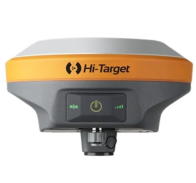
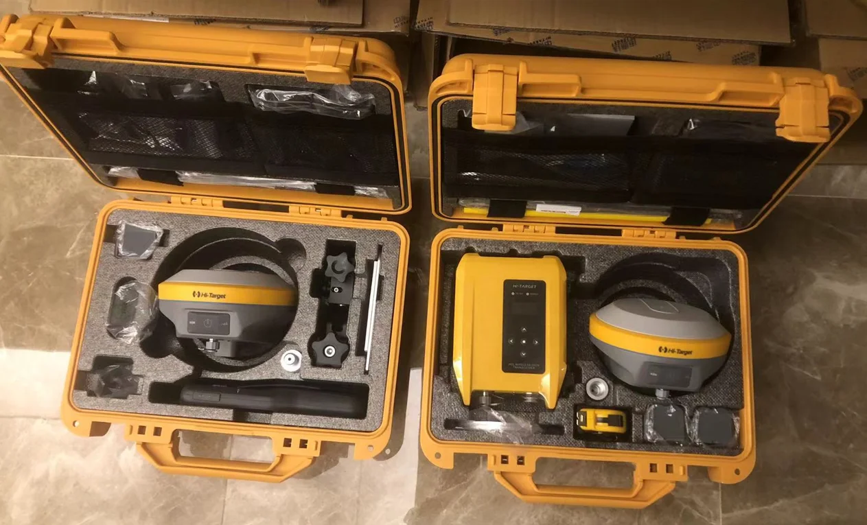
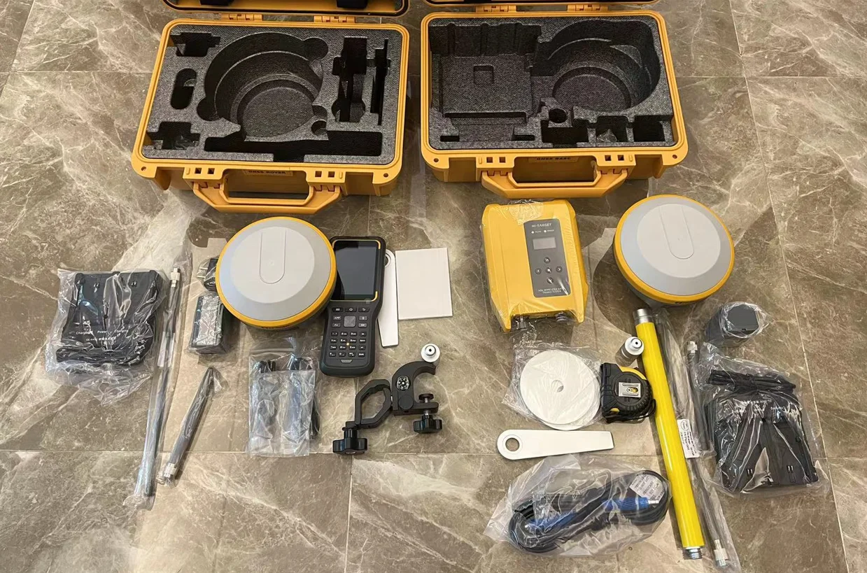
High Performance Hi Target V90 Plus GNSS RTK Receiver Rover and Base Station
- Category: >>>
- Supplier: Jiangsu Bangjie Trading Co. Ltd.
Share on (1600754355653):
Product Overview
Description
Product Description
High Performance Hi-Target V90 Plus GNSS RTK Receiver Rover and Base Station
V90 Plus GNSS RTK System
With a hi-tech, fully integrated design, the conveniently sized V90 Plus is one of the most flexible choices for any measuring task. Built-in Linux3.2.0 operating system, pre-loaded multiple smart applications such as tilt surveying, electronic bubble calibration, NFC and voice DIY. The V90 Plus GNSS system provides surveyor industry-leading GNSS operation.Specification
Model | V90 Plus | |||||||
SATELLITE SIGHNALS TRACKED SIMULTANEOUSLY | ||||||||
220 Channels | ||||||||
GPS | Simultaneous L1C/A, L2C, L2E, L5 | |||||||
GLONASS | Simultaneous L1C/A, L1P, L2C/A (GLONASS M only), L2P | |||||||
Galileo | Simultaneous E1 BOC, E5A, E5B, E5AltBOC | |||||||
BDS | B1, B2 | |||||||
SBAS | L1 C/A, L5 | |||||||
555 Channels (Optional) | ||||||||
GPS | L1C/A, L1C, L2C, L2P, L5 | |||||||
GLONASS | L1C/A, L2C, L2P, L3, L5 | |||||||
BeiDou | B1, B2, B3 | |||||||
Galileo | E1, E5A AltBOC, E5a, E5B, E6 | |||||||
IRNSS | L5 | |||||||
SBAS | L1, L5 | |||||||
QZSS | L1C/A, L1C, L2C, L5,L6 | |||||||
L-band | Up to5 channels | |||||||
TerraStar Correction Services4 | ||||||||
POSITIONING PERFORMANCE2 | ||||||||
Hot Start | Typically< 10s | Cold Star | Typically< 15s | |||||
High-Precision Static | ||||||||
Horizontal | 2.5 mm + 0.1 ppm RMS | Vertical | 3.5 mm + 0.4 ppm RMS | |||||
Static and Fast Static | ||||||||
Horizontal | 2.5mm+0.5ppm RMS | Vertical | 5mm+0.5ppm RMS | |||||
Post Processing Kinematic (PPK / Stop & Go) GNSS Surveying | ||||||||
Horizontal | 8mm+1ppm RMS | Vertical | 15mm+1ppm RMS | |||||
Initialization time | Typically 10 minutes for base while 5 minutes for rover | |||||||
Initialization reliability | Typically > 99.9% | |||||||
Real Time Kinematic(RTK) Surveying | ||||||||
Single Baseline | ||||||||
Horizontal | 8mm+1ppm RMS | Vertical | 15mm+1ppm RMS | |||||
Network RTK | ||||||||
Horizontal | 8mm+0.5ppm RMS | Vertical | 15mm+0.5ppm RMS | |||||
Initialization time | Typically 2-10s | |||||||
Initialization reliability | Typically > 99.9% | |||||||
Code Differential GNSS Positioning | ||||||||
Horizontal | 25cm+1ppm RMS | Vertical | 50cm+1ppm RMS | |||||
SBAS | 0.50m Horizontal, 0.85m Vertical | |||||||
COMMUNICATION | ||||||||
Network Communication | ||||||||
Fully integrated, fully sealed internal WCDMA, compatible with GPRS, GSM Wifi frequency is 2.4G, supports the standard protocol 802.11b/g/n Network RTK (via CORS) range20-50km | ||||||||
Hi-Target Advanced Internal UHF Radio | ||||||||
Frequency | 403-473MHz | |||||||
Transmitting power | 1W, 2W, 4W adjustable | |||||||
Transmitting linkrate | 9.6Kbps, 19.2Kbps | |||||||
Support multiple protocols | ||||||||
Working range | 3-5km typically, 8-10km optimal | |||||||
SATEL Internal UHF Radio (Optional) | ||||||||
Frequency | 403-473MHz | |||||||
Transmitting power | 0.1W~1W adjustable | |||||||
Transmitting speed | 9.6Kbps, 19.2Kbps | |||||||
Supports multiple communication protocol | ||||||||
Working range | 3-5km typically, 8-10km optimal | |||||||
HI-TARGET External UHF Radio | ||||||||
Frequency | 460MHz with 116 channels | |||||||
Transmitting power | 5W, 10W, 20W, 30W adjustable | |||||||
Transmitting speed | Up to 19.2Kbps | |||||||
Working range | 8~10km typically, 15~20km optimal | |||||||
Advanced External UHF Radio (Optional) | ||||||||
Frequency | 410~470MHz | |||||||
Transmitting power | 5W/25W | |||||||
Compatible with third party radio | ||||||||
Working range | 8~10km typically, 15~20km optimal | |||||||
HARDWARE | ||||||||
Physical | ||||||||
Dimensions (W x H) | 153mm x 83mm (6.02inch x 3.27inch) | |||||||
Weight | 950g (2.09lb)without internal batter | |||||||
Operating temperature | -40℃~+75 ℃(-40 ℉ ~+167 ℉) | |||||||
Storage temperature | -55ºC to +85ºC (-67ºF to +185ºF) | |||||||
Humidity | 100%, considering | |||||||
Water/dustproof | IP67 dustproof, protected from temporary immersion to depth of 1m (3.28ft). | |||||||
Shock and vibration | Designed to survive a 2m(6.56ft) natural fall onto concrete. | |||||||
Electrical | ||||||||
Power 6V to 28V DC external power input Power consumption ≤ 3.5W Automatic switching between internal power and external power Rechargeable, removable 7.4V, 5000mAh Lithium-ion battery in internal battery compartment | ||||||||
Internal Battery Life | ||||||||
Static more than 12 hours RTK Rover (UHF/GPRS/3G) 10 hours RTK base more than 8 hours | ||||||||
I/O Interface | ||||||||
Bluetooth, NFC,standard USB2.0port ,TNC antenna connector RS232 serial port,DC power input (5-pin), MicroSD card port | ||||||||
Tilt Survey System | ||||||||
Electronic Bubble | ||||||||
WebUI | ||||||||
SYSTEM CONFIGURATION | ||||||||
System | ||||||||
Data storage | 16GB Internal storage+ Internal Micro SD Card memory (Support up to 32GB extension) | |||||||
Record GNS and Rinex format simultaneously | ||||||||
Data Formats | ||||||||
(1Hz positioning output, up to 50Hz - depends on installed option) CMR: sCMRx, CMR, CMR+input and output RTCM: RTCM 2.1, 2.2, 2.3,3.0, 3.1, 3.2 input and output Navigation outputs ASCII: NMEA-0183 GSV, AVR, RMC, HDT, VGK, VHD, ROT, GGK, GGA, GSA, ZDA, VTG, GST, PJT, PJK, BPQ, GLL, GRS, GBS Navigation outputs binary: GSOF | ||||||||
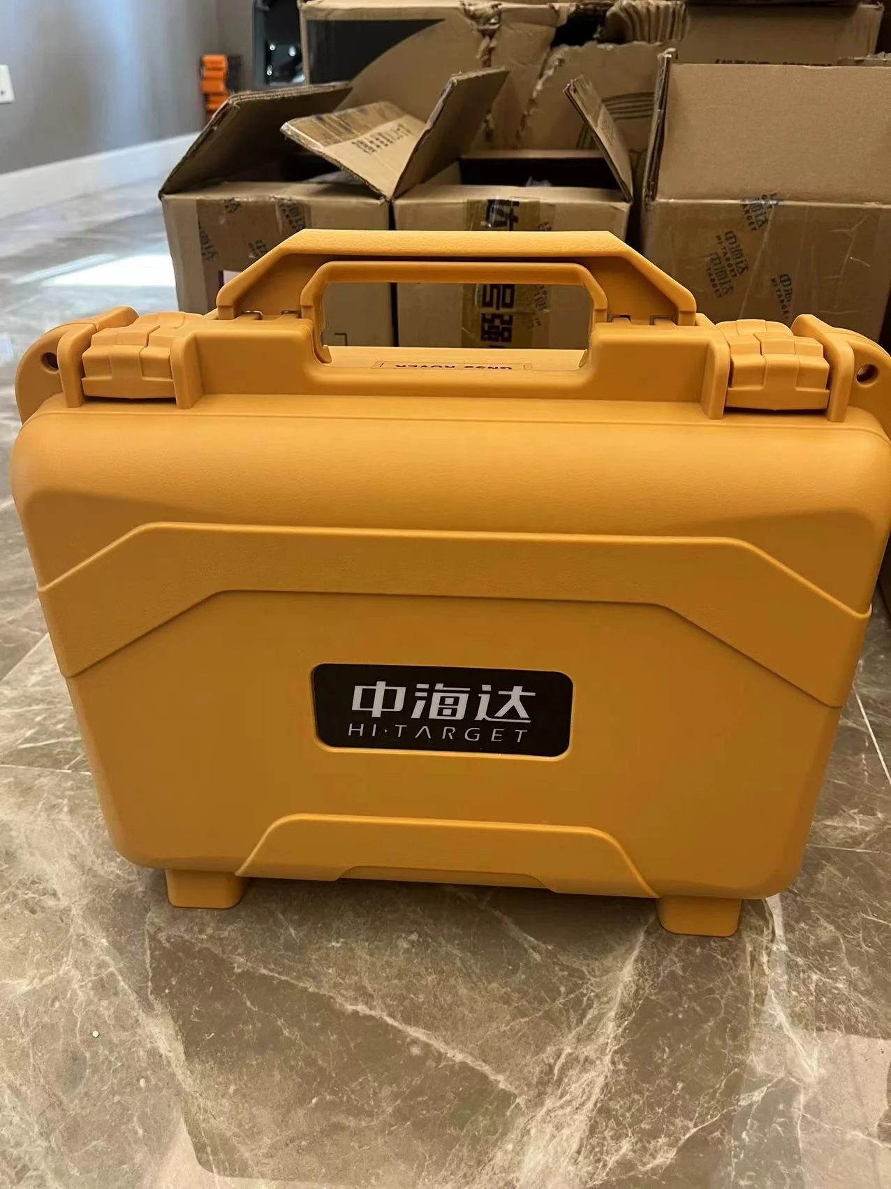
Packing & Delivery

Packing :
V90 plus GNSS RTK1 set packed in 3 cartons:
45*25*40cm (6kg)
45*25*40cm (6kg)
145*17*14cm(5kg)
Company Profile

Jiangsu Bangjie Trading Co., Ltd.
Jiangsu Bangjie Trading Co., Ltd. is a comprehensive trading company whose main business is surveying instruments, building materials and international trade. The company was registered in Nanjing, Jiangsu Province, the only megacity in the Yangtze River Delta. The company combined domestic sales with international trade earlier and was always guided by customer needs.
The company currently has three departments: surveying instrument department, building materials department and international trade department. We have a group of professionals who have been engaged in related industries for many years. We can provide you with more authoritative and convenient pre-sale consultation, sales cooperation, after-sales coordination and guidance, and provide comprehensive services.
At present, the company's main surveying instruments are: total station, GPS RTK, UAV, theodolite,plummet,auto level,laser rangefinder and surveying accessories.
Our Advantages
1. More than 20 years of experience in the trade field.
2. Combined domestic sales with international trade earlier and was always quided by customer needs.
3. Provide more authoritative and convenient pre-sale consultation, sales cooperation, after-sales coordination and guidance, and provide comprehensive services.
4. All products will have been strictly quality checked in factory before sending out and all products have one year warranty.


FAQ
1. who are we?
We are based in Jiangsu, China, start from 2017,sell to Africa(30.00%),Southeast Asia(16.00%),Mid East(11.00%),Eastern Asia(10.00%),South America(10.00%),Central America(5.00%),South Asia(5.00%),Southern Europe(5.00%),North America(4.00%),Eastern Europe(4.00%). There are total about 51-100 people in our office.
2. how can we guarantee quality?
Always a pre-production sample before mass production;
Always final Inspection before shipment;
3.what can you buy from us?
GNSS RTK,Total station,Level,Survey accessory,laser rangefinder
4. why should you buy from us not from other suppliers?
1.More than 20 years of experience in the trade field.
2.All products will have been strictly quality checked in factory before sending out and all products have one year warranty.
5. what services can we provide?
Accepted Delivery Terms: FOB,CFR,CIF,EXW,FAS,CIP,FCA,CPT,DEQ,DDP,DDU,Express Delivery,DAF,DES;
Accepted Payment Currency:USD,EUR,JPY,CAD,AUD,HKD,GBP,CNY,CHF;
Accepted Payment Type: T/T,L/C,D/P D/A,MoneyGram,Credit Card,PayPal,Western Union,Cash,Escrow;
Language Spoken:English,Chinese,Spanish,Japanese,Portuguese,German,Arabic,French,Russian,Korean,Hindi,Italian
We Recommend


New Arrivals
New products from manufacturers at wholesale prices


