
Hi Target V200 Cheap Gps Survey Equipment Price Measurement Instruments Gnss Rover
- Category: >>>
- Supplier: Huipu Opto-Electronic Instrument (Zhenjiang) Co. Ltd.
Share on (1600797952503):
Product Overview
Description
Products Description

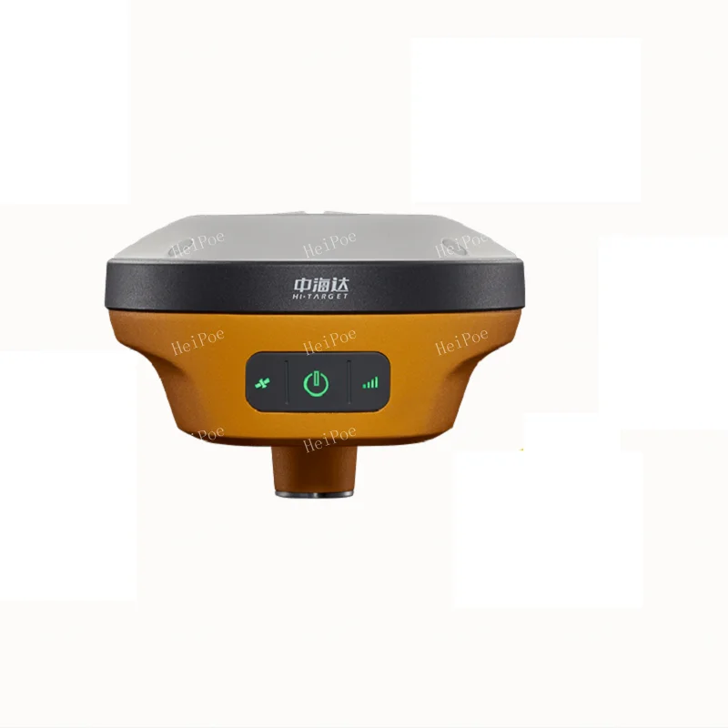
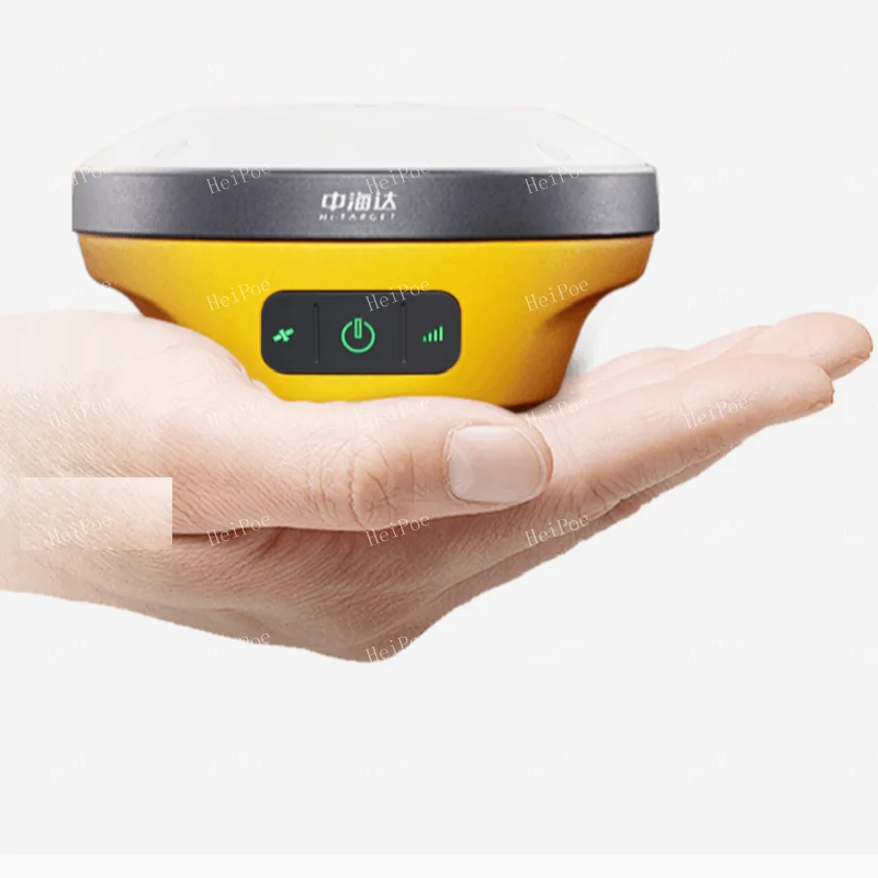
Lightweight compact/fast measurement
Hi-Target new generation RTK V200
With the concept of lightweight and compact, the operation becomes simpler and the measurement efficiency is quickly improved
With the concept of lightweight and compact, the operation becomes simpler and the measurement efficiency is quickly improved


Light and small work is not tired
Light EPP material instrument case, strong wear resistance and impact resistance
Lightweight design, full container reduction of 50%
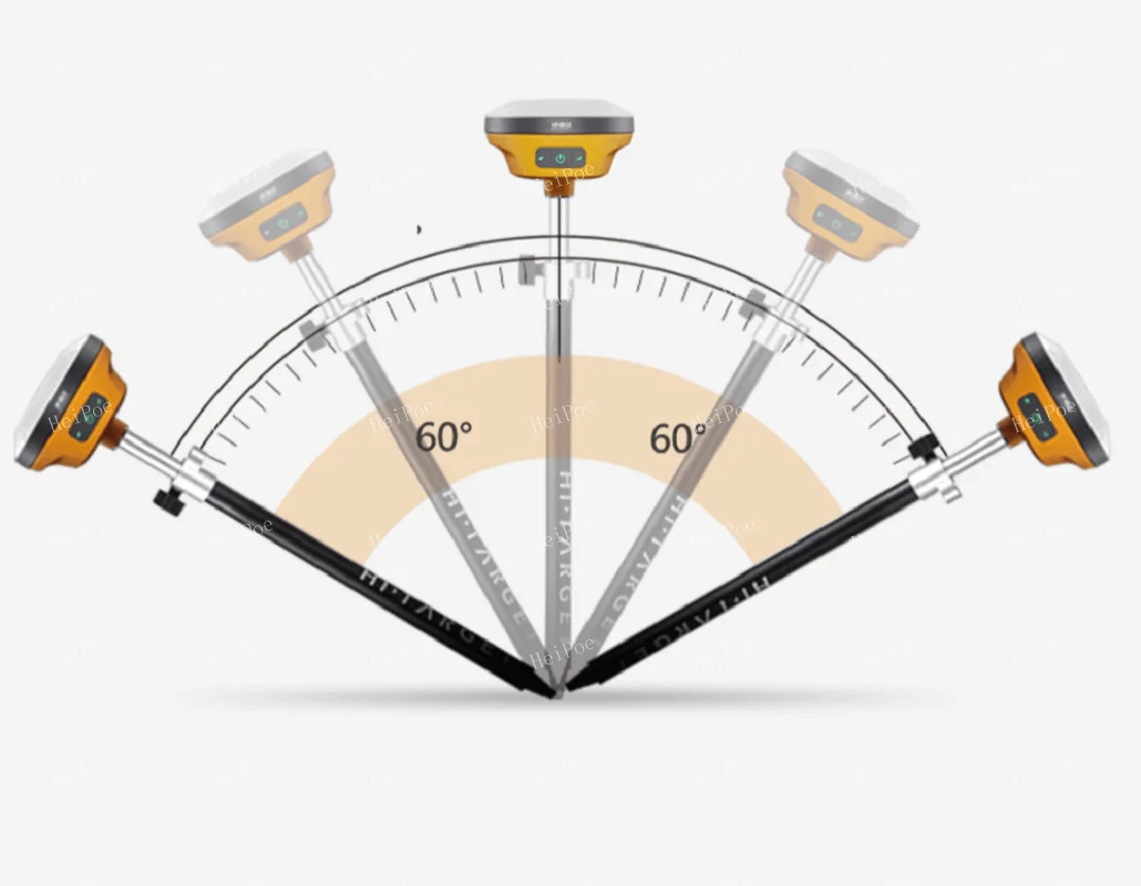
The center bar can shrink 1.25M, which makes the self-driving field more portable
Lightweight design, full container reduction of 50%
The center bar can shrink 1.25M, which makes the self-driving field more portable

Full constellation, full band, fixed block
Support Beidou-3 satellite signals
Search + solution satellite up to 50+
Model receive more sensitive, strong adaptive anti-interference
Support single beidou solution
Search + solution satellite up to 50+
Model receive more sensitive, strong adaptive anti-interference
Support single beidou solution

New inertial guide, shake can be measured
8 seconds fast initialization, stable and not easy to exit
High frequency no delay, that is, spot measurement
High frequency no delay, that is, spot measurement

Built-in full protocol radio +4G network
High, medium and low power adjustable, maximum 2W
Transceiver integrated, typical distance 7 km
Built-in eSIM card, send 4G traffic for three years
Transceiver integrated, typical distance 7 km
Built-in eSIM card, send 4G traffic for three years

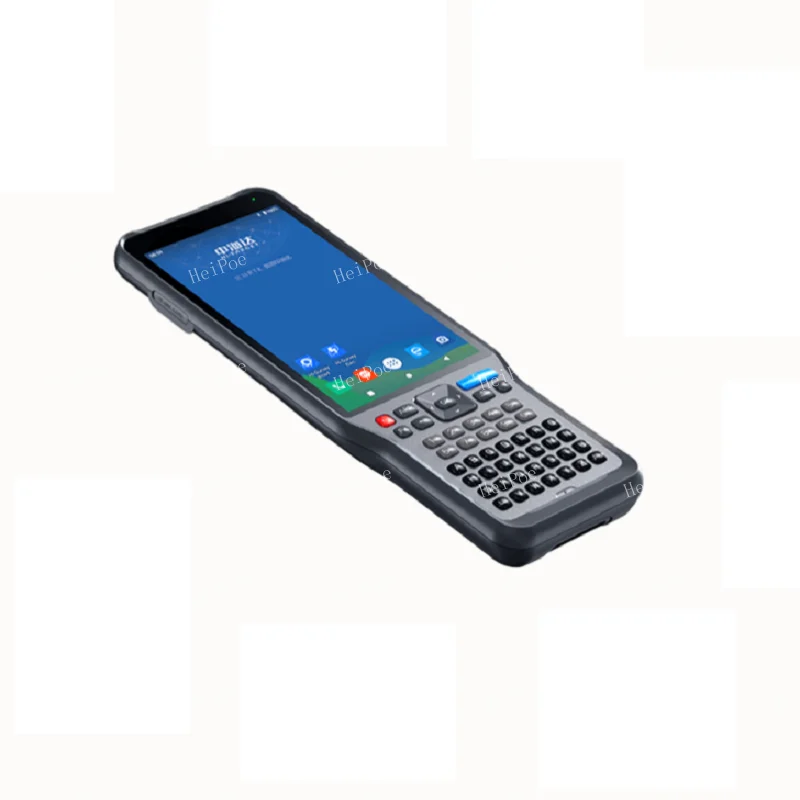
Oversized IHand55 Hand book
Octa-core processor, 5.5-inch highlighted touch screen
Built-in eSIM card
Android10 for smoother operation
Built-in eSIM card
Android10 for smoother operation
Specification
RTK V200 technical parameters | ||||||
GNSS configuration | Number of channels: 660 | |||||
BDS: B1I,B2I,B3I,B1C.B2a | ||||||
GPS: L1, L2, L5 | ||||||
GLONASS: L1, L2 | ||||||
GALILIEO: E1, E5a, E5b | ||||||
SBAS: Support | ||||||
QZSS: L1,L2,L5 | ||||||
Output format | ASCII: NMEA-0183, binary code | |||||
Positioning output frequency | 1Hz~20Hz | |||||
Static data format | GNS, Rinex dual format static data | |||||
Difference format | CMR, RTCM2.X, RTCM3.0, RTCM3.2 | |||||
Network mode | VRS, FKP, MAC; support NTRIP protocol | |||||
System Configuration | operating system | Linux operating system | ||||
Start Time | 3 seconds | |||||
data storage | Built-in 8GB ROM, supports automatic storage of static data | |||||
Accuracy and reliability [1] | RTK positioning accuracy | Plane: ±(8+1×10⁻⁶D) mm (D is the distance between the measured points) | ||||
Elevation: ±(15+1×10⁻⁶D) mm (D is the distance between the measured points) | ||||||
Static positioning accuracy | Plane: ±(2.5+0.5×10⁻⁶D) mm (D is the distance between the measured points) | |||||
Elevation: ±(5+0.5×10⁻⁶D) mm (D is the distance between the measured points) | ||||||
DGPS positioning accuracy | Plane accuracy: ±0.25m+1ppm; elevation accuracy: ±0.50m+1ppm | |||||
SBAS positioning accuracy | 0.5m | |||||
Initialization time | <10 seconds | |||||
Initialization reliability | >99.99% | |||||
Communication unit | I/O port | USB Type-C interface, SMA interface | ||||
Built-in 4G network communication | Built-in eSIM4 card, including 3 years Internet access fee, you can connect to the Internet after power on | |||||
WiFi communication | 802.11 a/b/g/n access point and client mode, can provide WiFi hotspot service | |||||
blue tooth communication | blue tooth® 4.2/2.1+EDR, 2.4GHz | |||||
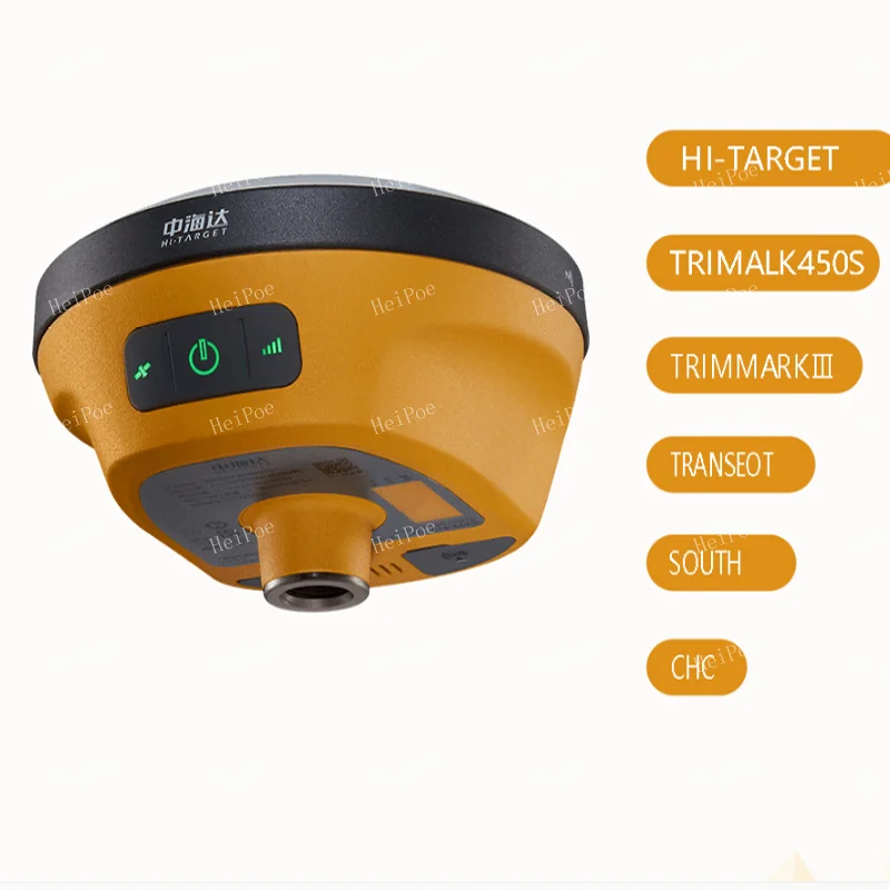
Built-in radio | Built-in transceiver station: | |||||
Power: 0.5W/1W/2W adjustable | ||||||
Frequency band: 410MHz~470MHz | ||||||
Protocol: HI-TARGET, TRIMTALK450S, TRIMMARKⅢ, TRANSEOT | ||||||
Number of channels: 116 (16 of which can be configured) | ||||||
sensor | Electronic bubble | Realize smart alignment | ||||
Tilt measurement | Built-in high-precision inertial navigation, automatic attitude compensation, 8mm+0.7mm/°tilt (accuracy within 30°<2.5cm) | |||||
User Interface | button | A power button | ||||
LED indicator light | Satellite lights, signal lights, power lights | |||||
WEB UI | Built-in WEB page to realize receiver setting and status check | |||||
Function application | Advanced Features | OTG function, NFC IGRS, WebUI interaction, U disk firmware upgrade | ||||
Smart application | Smart base station, smart voice, function self-check, smart CORS | |||||
Remote Service | News push, online upgrade, remote control | |||||
cloud service | Equipment management, location services, collaborative operations, data analysis | |||||
Physical characteristics | Host battery | Built-in high-capacity lithium battery 6800mAh/7.4V, network mobile station working time is more than 10 hours[2] | ||||
External power supply | Support USB port charging and external power supply | |||||
size | Φ132mmx67mm | |||||
weight | ≤0.82kg | |||||
Power consumption | 4.2W | |||||
material | The shell is made of magnesium alloy material | |||||
Environmental characteristics | Dustproof and waterproof | IP68 | ||||
Anti-fall | Resistance to natural drop of 2m high measuring rod | |||||
Relative humidity | 100% non-condensing | |||||
Operating temperature | -30℃~+70℃ | |||||
storage temperature | -40℃~+80℃ | |||||
Company Profile

FAQ
1. What kind payment method we accept?
T/T, L/C at sight, Western Union, Trade Assurance on Alibaba, MoneyGram and PayPal
Note: Customer will be requested to pay 4% transaction fee upon total amount charged by EBAY
2. How can you guarantee payment safety?
Our company supports TRADE ASSURANCE service. If you will choose payment through ALIBABA TRADE ASSURANCE service, you payment will
be guaranteed. Because we are not able to receive payment until you confirm goods receipt
3. What kinds of shipment for goods and how long time it takes?
Our company supports DHL, FEDEX, UPS, TNT, CHINA POST, by sea and other methods. Shipping time is 3-5 days from payment receipt
4. Does your company ship battery or not?
Our company can receive battery order and ship to customer normally, except a few special countries
5. Do you have other items not displayed on your website?
Yes, our company supplies full survey range products. If you are looking for product not displayed on our website. Please contact us freely. We will reply you on time
Our Advantages
Our warranty policy:
1.For GNSS/RTK products we offer one year and half a year warranty.
2.For optical instruments (total station, theodolite, Level), we offer 1 years warranty. For accessories we offer 6 months
warranty.
3.Product in warranty please sends us photos to show the problem. And then will decide to send you parts or you send the
instrument back to us to repair, We are responsible for the double-run freight and other cost, Please make sure to contact us
first instead of sending the damaged parts directly to us. Sometime, our service people can repair
your product local.
4.For problem out of the warranty period or warranty liability,we will judge the problem and quoted for you.You need to pay
double-run freight and the maintenance cost.
5.For all instrument we provide life-long technical support.Remark:Improper use of the instrument and man made damage of the
instrument is notcovered in warranty liability.Warra
Our Technical Support:
Before any shipment we will have quality check person to give the instrument a careful quality check (software installation and
test for GNSS product).
For all GNSS and optical instrument, you will get the user manual and operating video.
For green hand users we offer free online training (especially for GNSS products), regarding receiver configuration, survey
software on controller and post process software operation. If customer needed we also offer charged on site training.
For all of the products we offer lifelong and 24 hours technical support.
Special services:
If you have a survey project, and you are finding a most cost-effective and efficient way to handle it. Just tell us your project
specification, we will feedback with professional suggestions as reference. We offer GNSS raw data process and CAD drawing for
survey field end users. If you have some broken instrument, and want to re-pick up into normal use, send it to use we offer
professional repair service for all kinds of survey equipment.
We Recommend


New Arrivals
New products from manufacturers at wholesale prices


