
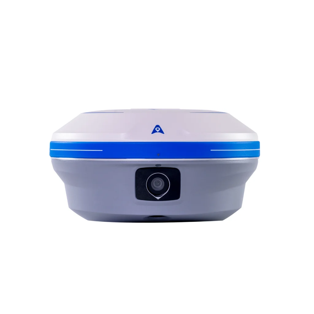
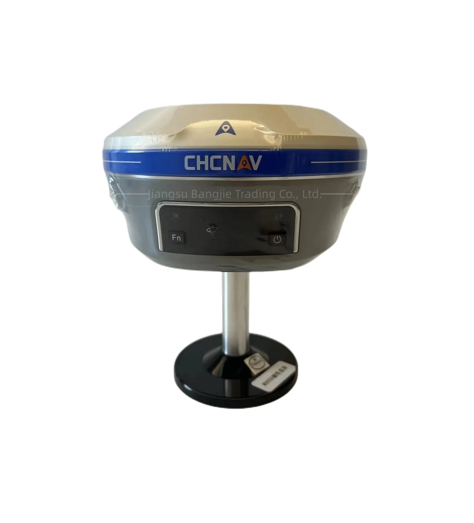
CHCNAV I93/X16pro Gnss RTK base and rover with visual and IMU 1408 channels for land surveying
- Category: >>>
- Supplier: Jiangsu Bangjie Trading Co. Ltd.
Share on (1600901250086):
Product Overview
Description
Product Description
Specification
GNSS Performance | ||
Product name | CHC X16 pro | |
channels | 1408 | |
BDS | B1I,B2I,B3I,B1C,B2a,B2b* | |
GPS | L1C/A,L1C,L2C,L2P,L5 | |
GLONASS | G1,G2,G3 | |
Galileo | E1,E5a,E5b,E6* | |
QZSS | L1C/A,L1C,L2C,L5 | |
IRNSS | L5* | |
SBAS | L1C/A* | |
size | 152 mm*81 mm | |
GNSS Accuracies | ||
Real time kinematic (RTK) | H: 8 mm + 1 ppm RMS V: 15 mm + 1 ppm RMS | |
Initialization time:<10s | ||
Initialization reliability: >99.9% | ||
Post-processing kinematic (PPK) | H: 3 mm + 1 ppm RMS | |
V: 5 mm + 1 ppm RMS | ||
Post-processing static | H: 2.5 mm + 0.5 ppm RMV: 5 mm + 0.5 ppm RMS | |
Code differential | H: 0.4 m RMS V: 0.8 m RMS | |
Autonomous | H:1.5 m RMS | V: 2.5 m RMS | |
Visual survey | Typical 2~4 cm, range 2~15 m | |
Positioning rate | 1 Hz, 5 Hz and 10 Hz | |
Time to first fix | Cold start: < 45 s, Hot start: < 10 sSignal re-acquisition: < 1 s | |
IMU update rate | 200 Hz | |
Till angle | 0-60° | |
RTK tilt-compensated | Additional horizontal pole-tilt uncertainty typically less than 10 mm + 0.7 mm/° tilt | |
Environments | ||
Temperature | Operating: -40°C to +65°C (-40°F to +149°F) Storage: -40°C to +85°C (-40°F to +185°F) | |
Humidity | 100% non-condensation | |
Ingress protection | IP67 (according to IEC 60529) | |
Drop | Survive a 2-meter pole-drop | |
Vibration | Compliant with ISO 9022-36-08 and MIL-STD-810G- 514.6-Cat.24 | |
Waterproof and breathable membrane | Prevent water vapor from entering under harsh environments | |
Electrical | ||
Power consumption | UHF/ 4G RTK Rover w/o camera: Typical 2.8 W Visual Stakeout/Visual Survey: Typical 4 W | |
Li-ion battery capacity | Built-in non-removable battery9,600 mAh, 7.4 V | |
Operating time on internal battery | UHF/ 4G RTK Rover w/o camera: up to 34 h Visual Stakeout/Visual Survey: up to 24 h UHF RTK Base: up to 16 h Static: up to 36 h | |
External power input | 9 V DC to 28 V DC | |
Hardware | ||
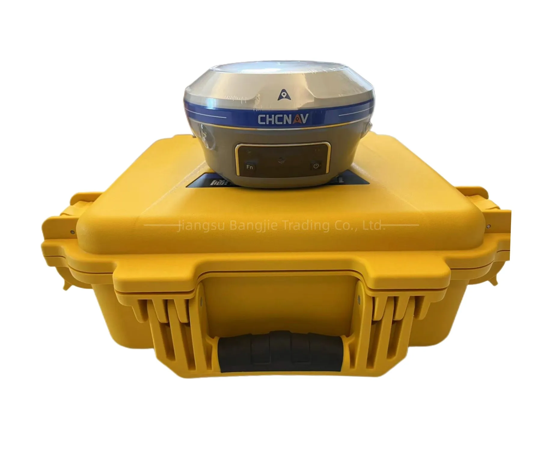
Size (D*H) | Φ 152 x 81 mm (Φ 5.98 x 3.19 in) | |
Weight | 1.15 kg (2.54 lb) | |
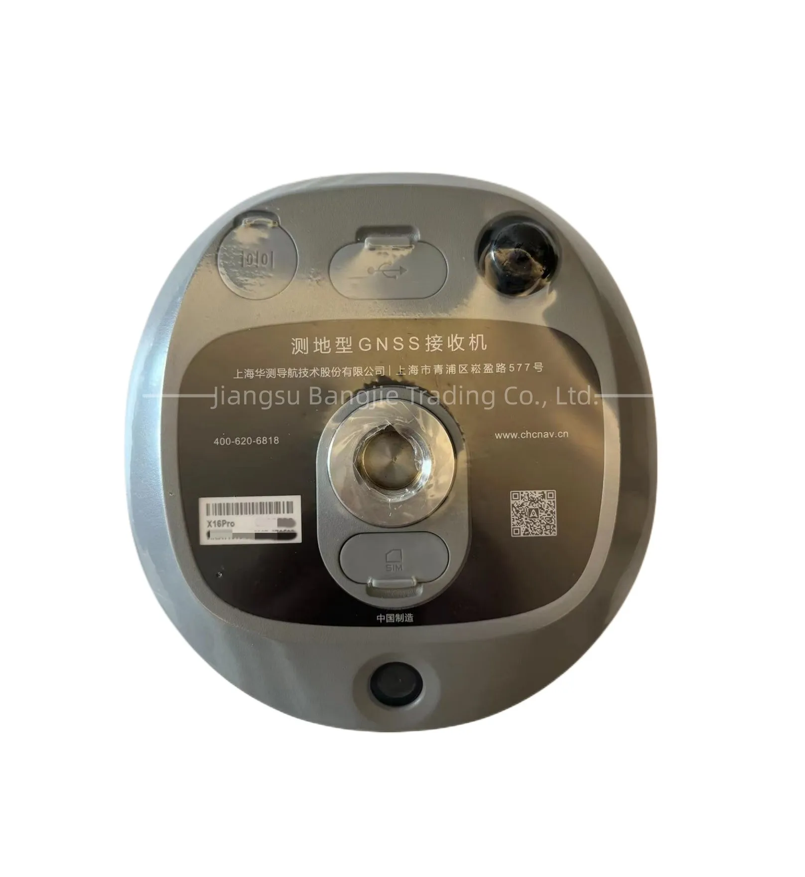
Front panel | 1.1'' OLED Color Display 2 LED, 2 physical buttons | |
Tilt sensor | Calibration-free IMU for pole-tilt compensation. Immune to magnetic disturbances. E-Bubble leveling | |
Cameras | ||
Sensor pixels | Global shutter with 2 MP & 5 MP | |
Field of view | 75° | |
Video frame rate | 25 fps | |
Image group capture | Method: video photogrammetry. Rate: typically 2 Hz, up to 25Hz. Max. capture time: 60s with an image group size of appr. 60MB. | |
Illumination | Starlight-grade camera. OmniPixel® -GS technology. Maintain full color at illumination levels as low as 0.01 lux. | |
Communication | ||
SIM card type | Nano-SIM card | |
Network modem | Integrated 4G modem: TDD-LTE, FDD-LTE, WCDMA, EDGE, GPRS, GSM | |
Wireless connection | NFC for device touch pairing | |
Wi-Fi | Wi-Fi IEEE 802.11a/b/g/n/ac, access point mode | |
Bluetooth® | 5.0 and 4.2 +EDR, backward compatible | |
Ports | 1 x 7-pin LEMO port (RS-232) 1 x USB Type-C port (external power, data download, firmware update) 1 x UHF antenna port (TNCfemale) | |
Built-in UHF radio | Rx/Tx: 410 - 470 MHz Transmit Power: 0.5 W to 2 W Protocol: CHC, Transparent, TT450, Satel Link rate: 9 600 bps to 19 200 bps Range: Typical 3 km to 5 km, up to 15 km with optimal conditions | |
Data formats | RTCM 2.x, RTCM 3.x, CMR input / output HCN, HRC, RINEX 2.11, 3.02 NMEA 0183 output NTRIP Client, NTRIP Caster | |
Data storage | 8 GB internal memory. Support 128 GB external expansion | |
Compliance with Laws and Regulations | ||
International standards | NGS Antenna Calibration, IEC 62133-2:2017+A1, IEC 62368- 1:2014, UN Manual Section 38.3 | |
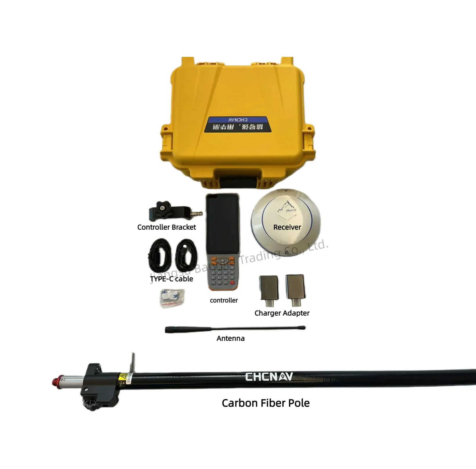
Packing & Delivery


Standard package including carrying case and carton
Company Profile


Jiangsu Bangjie Trading Co., Ltd. is a comprehensive trading company whose main business is surveying instruments, building materials and international trade. The company was registered in Nanjing, Jiangsu Province, the only megacity in the Yangtze River Delta. The company combined domestic sales with international trade earlier and was always guided by customer needs.
The company currently has three departments: surveying instrument department, building materials department and international trade department. We have a group of professionals who have been engaged in related industries for many years. We can provide you with more authoritative and convenient pre-sale consultation, sales cooperation, after-sales coordination and guidance, and provide comprehensive services.
At present, the company's main surveying instruments are: total station, GPS RTK, UAV, theodolite,plummet,auto level,laser rangefinder and surveying accessories.
FAQ
1. who are we?
We are based in Jiangsu, China, start from 2017,sell to Africa(30.00%),Southeast Asia(16.00%),Mid East(11.00%),Eastern Asia(10.00%),South America(10.00%),Central America(5.00%),South Asia(5.00%),Southern Europe(5.00%),North America(4.00%),Eastern Europe(4.00%). There are total about 51-100 people in our office.
2. how can we guarantee quality?
Always a pre-production sample before mass production;
Always final Inspection before shipment;
3.what can you buy from us?
GNSS RTK,Total station,Level,Survey accessory,laser rangefinder
4. why should you buy from us not from other suppliers?
1.More than 20 years of experience in the trade field.
2.All products will have been strictly quality checked in factory before sending out and all products have one year warranty.
5. what services can we provide?
Accepted Delivery Terms: FOB,CFR,CIF,EXW,FAS,CIP,FCA,CPT,DEQ,DDP,DDU,Express Delivery,DAF,DES;
Accepted Payment Currency:USD,EUR,JPY,CAD,AUD,HKD,GBP,CNY,CHF;
Accepted Payment Type: T/T,L/C,D/P D/A,MoneyGram,Credit Card,PayPal,Western Union,Cash,Escrow;
Language Spoken:English,Chinese,Spanish,Japanese,Portuguese,German,Arabic,French,Russian,Korean,Hindi,Italian
We Recommend


New Arrivals
New products from manufacturers at wholesale prices


