
New Technology Visual Positioning 1408 Channels Hi Target Vrtk2 Vrtk Image Survey Gps Gnss Receiver
- Category: >>>
- Supplier: Shanghai Apekstool Optoelectronic Technology Co. Ltd.
Share on (1600920854553):
Product Overview
Description
Product Description
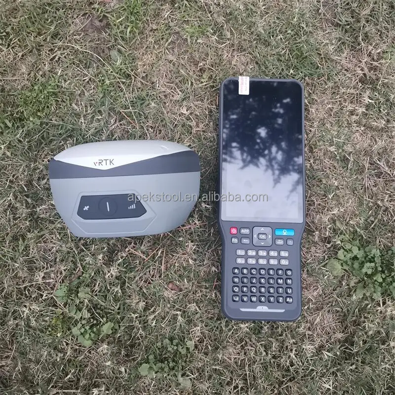
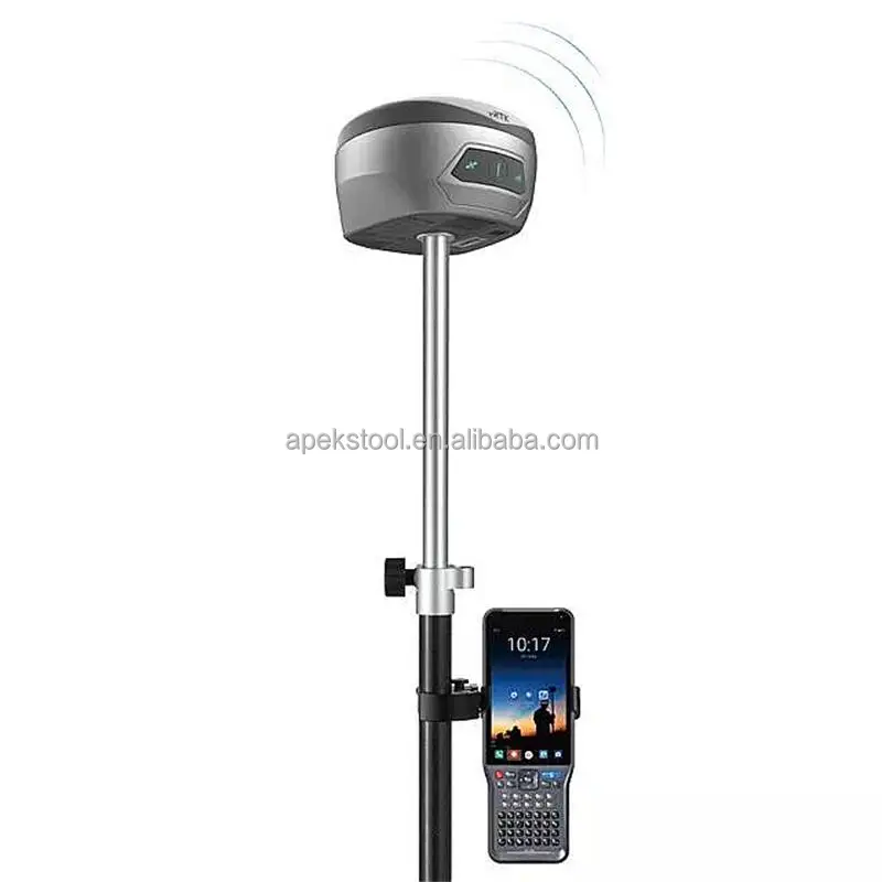
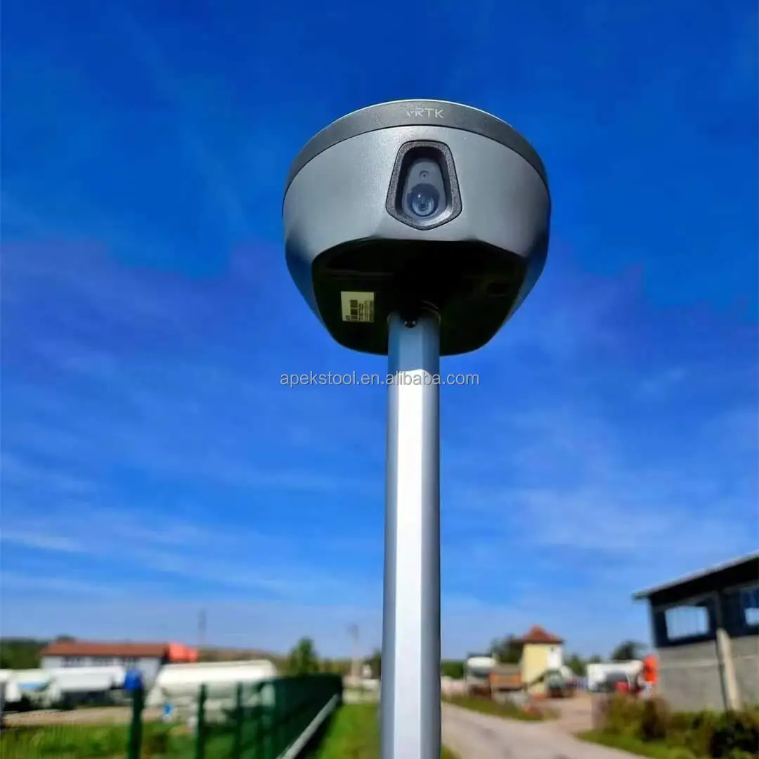
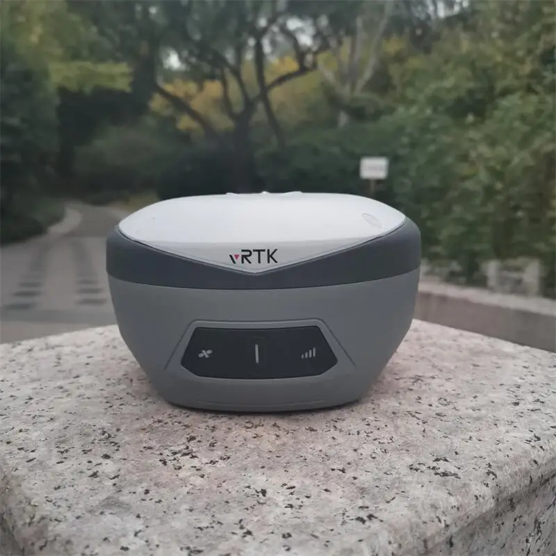
Easy Initializtion Dual Cameras Hi Target Vrtk2 Vrtk Live View Stakeout Base and Rover Rtk
*the New IMU GNSS RTK with Visual Positioning Technology
Equipped with professional dual cameras, vRTK is Hi-Target’s first lightweight and innovative visual RTK receiver product, which not only enables non-contact image surveying, breaking through the objective constraints of previous work, but also improves the speed of stakeout with the function of Live View Stakeout. It greatly improves the work efficiency of engineering users.
* Dual Cameras for Image Survey and Live View Stakeout
Non-contact measurement greatly improves the usable range of GNSS and efficient safe operation.
*Strong Signal and High-quality Data
New generation GNSS SOC chip with 1408 channels, supports new frequency points B1C, B2a, and B2b RTK decoding for Beidou-3 Satellites.
Introduction of multi-frequency anti-jamming technology and multi-step adaptive filtering technology to ensure strong signals, high-quality data, fast fix, and high accuracy.
*Abundant Industry Data Results
Abundant types of data results meet the needs of different industry applications.
Compatible with the mainstream modelling software to attain point cloud and 3D modelling in one step.
Compatible with the mainstream modelling software to attain point cloud and 3D modelling in one step.
Specification
Easy Use 1408 Channels Dual Cameras Visual GPS RTK Surveying Instruments vRTK/V5/vRTK2 gnss rtk base and rover | ||||
Configuration | Channels: 1408 | |||
BeiDou: BDS : B1I,B2I,B3I,B1C,B2a,B2b | ||||
GPS: L1C/A,L1C,L2P(Y),L2C,L5 | ||||
GLONASS: L1,L2 | ||||
GALILEO: E1,E5a,E5b,E6 | ||||
SBAS: L1,L2,L5 | ||||
IRNSS :L5 | ||||
QZSS : L1,L2,L5,L6 | ||||
Support the PPP service | ||||
Output format | ASCII: NMEA-0183, binary data | |||
Positioning output frequency | 1-20Hz | |||
Static data format | GNS and Rinex | |||
Differential format | RTCM2.X,RTCM3.X | |||
Network model | VRS, FKP, MAC; support NTRIP | |||
System Configuration | Operating system | Linux | ||
Data storage | Built-in 8GB ROM, support automatic cycle storage of static data | |||
Accuracy and Reliability | RTK Positioning | Horizontal: ±(8+1×10⁻⁶D)mm | ||
Vertical: ±(15+1×10⁻⁶D)mm | ||||
Static Positioning | Horizontal: ±(2.5+0.5×10⁻⁶D)mm | |||
Vertical: ±(5+0.5×10⁻⁶D)mm | ||||
DGPS Positioning | Horizontal:±0.25m+1ppm | |||
Vertical: ±0.50m+1ppm | ||||
SBAS Positioning | 0.5m | |||
Tilt measurement accuracy | 8mm+0.7mm/°tilt | |||
Image stakeout accuracy | Typical accuracy: 2cm | |||
Image measurement accuracy | 2cm ~ 4cm | |||
initialization time | <10s | |||
Initialization reliability | >99.99% | |||
Continued test at breakpoint | RTK measurements are still available during differential signal interruptions | |||
Pixels | Professional Dual HD Camera, 2MP & 5MP | |||
Futures | Support real scene stakeout, image measurement, working distance 2~15m | |||
Built-in Sim card Internal 4G mobile network:TDD-LTE,FDD-LTE,WCDMA,TD-SCDMA, EDGE,GPRS,GSM | ||||
I/O ports | USB type C interface; SMA interface | |||
WiFi | 802.11 b/g access point and client mode, WiFi hotspot available | |||
Bluetooth | Bluetooth® 4.0/2.1+EDR, 2.4GHz | |||
Transmitting power: 0.5W/1W/2W adjustable | ||||
Frequency: 410MHz-470MHz | ||||
Protocol: HI-TARGET,TRIMTALK450S,TRIMMARKⅢTRANSEOT,SOUTH,CHC,SATEL | ||||
Bands: 116 bands(16 bands are configurable) | ||||
Working Range: Typically 7km | ||||
HDL460A radio | Transmitting power: 10W/30W adjustable | |||
Working voltage: 9-16V | ||||
Frequency: 403MHz-473MHz | ||||
Protocol: HI-TARGET,TRIMTALK450S,TRIMMARKⅢTRANSEOT,SOUTH,CHC,SATEL | ||||
Bands: 116 bands(16 bands are configurable) | ||||
Transmission rate: 19.2kbps, 9.6kbps adjustable | ||||
Working Range: Typically 8-10 km ,optimal 15-20 km | ||||
Electronic bubble | Intelligent levelling | |||
Tilt correction system will continue to monitor the inclination of the centering rod, and compensate to correct the coordinates | ||||
User Interface | Button | Single button | ||
LED Lamp | LED light: satellite light, signal light, power light | |||
Advanced function | NFC IGRS, WebUI interaction, U disk firmware upgrade | |||
Intelligence application | intelligent voice, function self-test | |||
Remote service | Message push, online upgrade, remote control | |||
Cloud services | device management, location services, collaborative work, data analysis | |||
Operating temperature | -45℃~+75℃ | |||
Storage temperature | -55℃~+85℃ | |||
Humidity | 100% non-condensing | |||
Water/dustproof | IP68 dustproof, protected from temporary | |||
Anti-drop | Anti-2m high measuring rod natural drop | |||
GNSS battery | high-capacity li-ion battery 7000mAh, working time is better than 15 hours | |||
External power supply | USB 15W charging | |||
Dimensions | Φ130mm×80mm | |||
Weight | ≤0.97kg | |||
Power | 2.6W | |||
Material | The shell is made of magnesium alloy material | |||
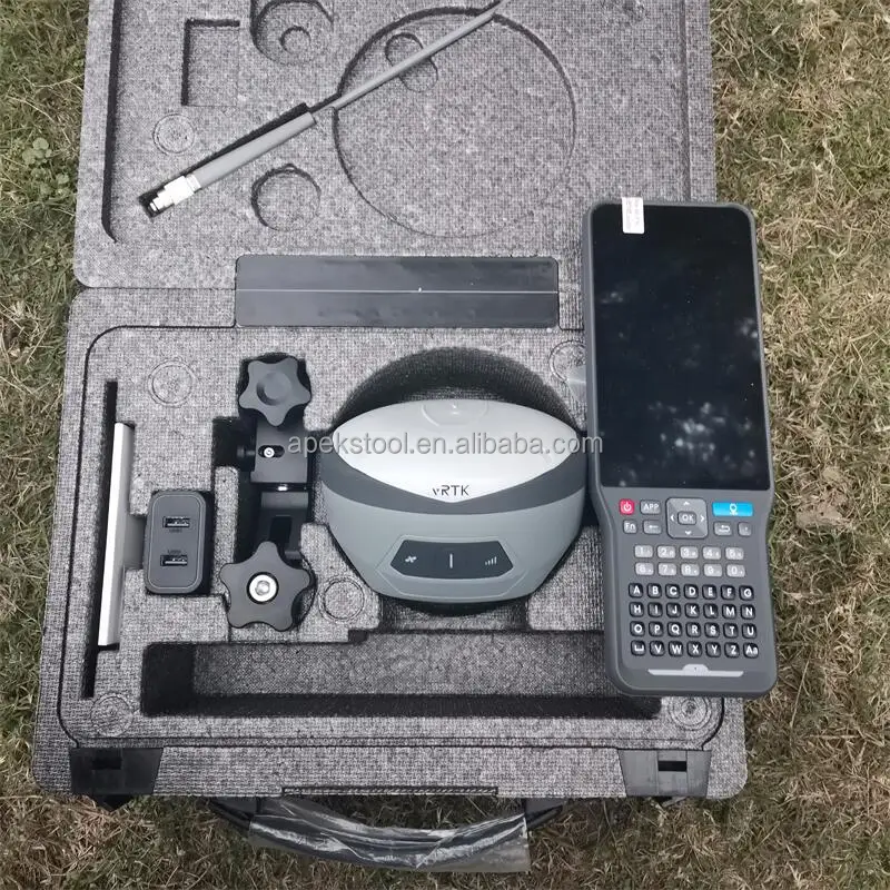
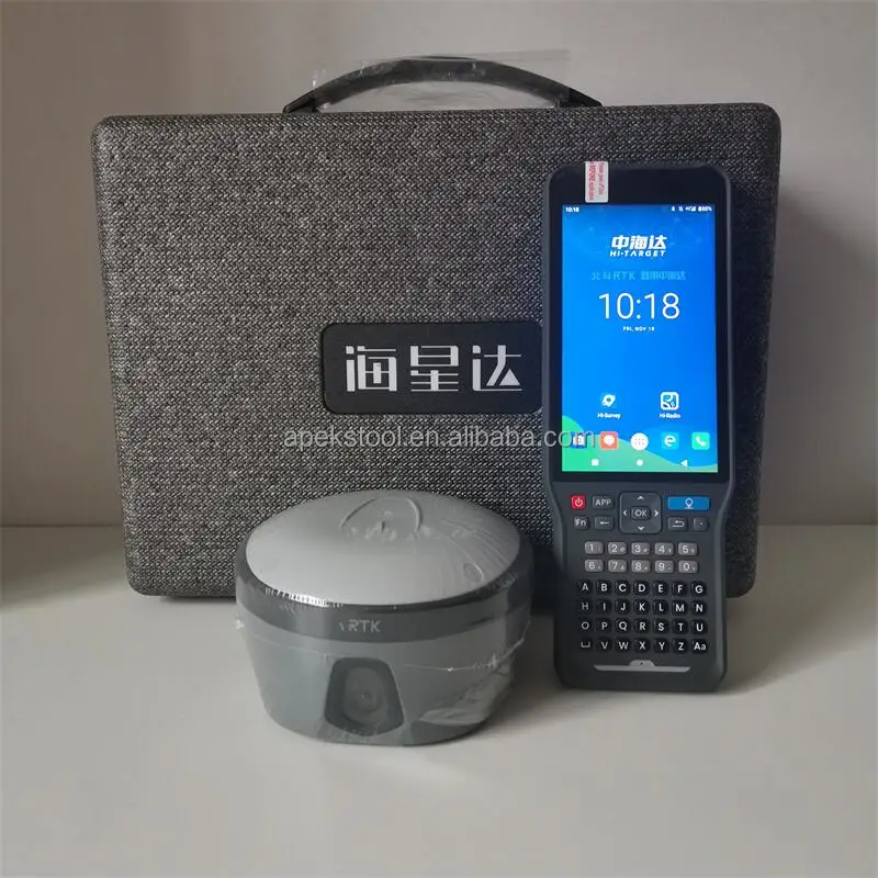
Packages

Company Profile
Shanghai Apekstool was founded and based in Shanghai, specializing in the manufacturing and sales of Surveying equipment. We are dedicated to being a professional provider for survey equipment. Our goal is to provide the best products and excellent service to our customers all over the world.
We are proud to guarantee that, with our strong technical background and communication capability, our sales/support engineers are able to answer your most complicated technical questions over the phone in English. That would save so much time for communication.
We have been involved in the geographic mapping industry for 6 years. We supply all products with reasonable prices and real-time support upon our own professional experience and high-quality supply chain.
We are proud to guarantee that, with our strong technical background and communication capability, our sales/support engineers are able to answer your most complicated technical questions over the phone in English. That would save so much time for communication.
Our business is growing and we invite you to be part of the success.


Contact us

Don't hesitated to send inquiry to us, the top 50 will get discount price!!!
Sales Engineer : Winni Jin
E-mail: winni.jin@apekstool.comWhatsapp/ Wechat /Phone Number: +86 18917981901
To achieve more efficient communication, We'd suggest to talk via Skype /Whatsapp /Wechat telephone directly when you have time.
To achieve more efficient communication, We'd suggest to talk via Skype /Whatsapp /Wechat telephone directly when you have time.
Customer Feedback


FAQ
Q: Who are we?
We are based in Shanghai, China and we are selling to Middle East, Africa, Southeast Asia, Eastern Asia, South America,North America, In almost every country we have customer representatives who can help us contact you.
Q: How do we process your order and give your warranty?
We can have order by the third party of Alibaba to ensure your order and payment safety.
We will process your order in our sales system, 1. to check machine appearance, 2. to register the machine permanent code, 3. to test machine fixed solution, 4. to pack and delivery. Our sales will follow up every step to the customer, giving you 100% assured experience and immersive online purchasing.
We have 12 months quality warranty and 24 hours online technical support
Q: What can you buy from us?
We have known brands GNSS RTK system , total station , theodolite , auto level , rotary laser level, drones and surveying
accessories. All products are new and original. Different brands and different price ranges of products can meet the needs of all customers. We can offer one-stop services.
Q: What services can we offer?
Accepted currencies of payment: USD, EUR, JPY, CAD, AUD, HKD, GBP, RMB, CHF.
Accepted payment methods: T/T, L/C, MoneyGram, Credit Card, PayPal, Western Union, Cash
Languages: English, Chinese, Spanish, Japanese,Portuguese,German, Arabic, French, Russian, Korean, Italian
Languages: English, Chinese, Spanish, Japanese,Portuguese,German, Arabic, French, Russian, Korean, Italian
We Recommend


New Arrivals
New products from manufacturers at wholesale prices


