
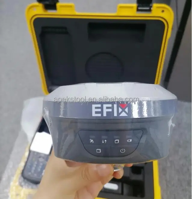
Full Satellite 1608 Channels Imu Rtk Efix F4 F7/F7 Base and Rover Gnss Receiver
- Category: >>>
- Supplier: Shanghai Apekstool Optoelectronic Technology Co. Ltd.
Share on (1600929645680):
Product Overview
Description
Product Description
High and Reliable Accuracy Smart Antenna Efix F4-F7/F7+ Gnss Rtk Base and Rover Receiver
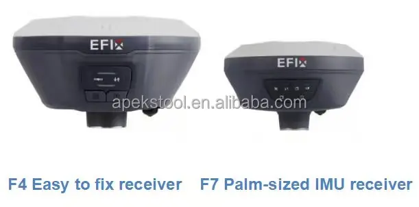
F7 GNSS Receiver | ||
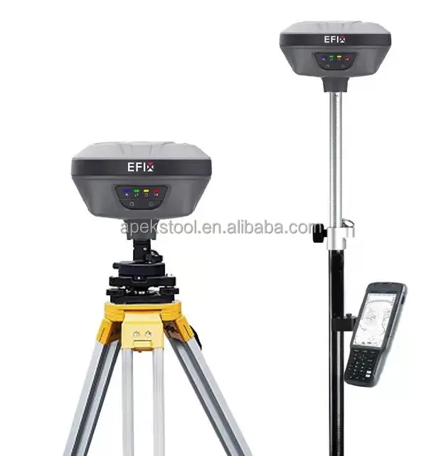
Rover Station (Receive) | ||
Palm-sized IMU-RTK with high accuracy 1.The F7 GNSS receiver integrated IMU-RTK technology provides a robust and accurate positioning in any circumstances. Unlike the standard MEMS-based GNSS receivers, the F7 GNSS IMU-RTK combines state-of-the-art GNSS RTK engine, a calibration-free high-end IMU sensor and advanced GNSS tracking capabilities to dramatically increase RTK availability and reliability. 2.The F7 automatic pole-tilt compensation boosts survey and stakeout speed by up to 30%. Construction and land surveying projects are achieved with high productivity and reliability pushing the boundaries of conventional GNSS RTK survey. 3.What's more, with all these features and performances, F7 is successfully designed to be only palm-size, which is only 0.73kg and perfectly fit in hand. | ||
F7+ | ||
Rover Station (Receive and transmit) | ||
BEST-IN-CLASS SIGNAL TRACKING 1.The integrated advanced 1608-channel GNSS technology takes advantage of GPS, Glonass, Galileo and BeiDou, in particular the latest BeiDou III signal, and provides robust data quality at all times. The F7+ extends GNSS surveying capabilities while maintaining centimeter-level survey-grade accuracy. GNSS surveying has never been more efficient. PORTABLE INTERNAL UHF BASE+ROVER 2.The F7+ features a built-in transceiver radio module compatible with major radio protocols, making it the perfect choice for a portable built-in UHF base and rover kit with fewer accessories. F7+ is a highly productive NTRIP rover when used with a handheld controller or tablet and connected to a GNSS RTK network. The F7+ is a highly rugged and reliable receiver without downtime used for surveying of any terrain, mapping, or construction site. | ||
F4 GNSS Receiver | ||
Base Station | ||
Versatile, rugged, accurate 1.The F4 GNSS receiver removes barriers to portability without sacrificing performance. Featuring full GNSS technology, it offers best-in-class GNSS signal tracking even in a harsh environment, enabling GNSS surveying beyond usual constraints. 2.The F4 GNSS receiver integrates positioning and communication technologies in a rugged unit that is designed to provide work flexibility. When RTK networks are unavailable at your job sites, just easily set up one F4 GNSS UHF base and use your F4 GNSS UHF rover to conduct your RTK survey. | ||
Specification
F7 ROVER GNSS Performance | ||
Channels | 1608 channels | |
GPS | L1,L2, L5 | |
GLONASS | L1, L2 | |
Galileo | E1, E5a, ESb | |
BeiDou | B1, B2, B3 | |
SBAS | L1 | |
QZSS | L1,L2, L5 | |
GNSS Accuracies | ||
Real time kinematics (RTK) | Horizontal: 8 mm+ 1 ppm RMS Vertical: 15 mm+ 1 ppm RMS Initialization time: < 10s Iitaliation rlability:> 99.9% | |
Post-processing kinematics (PPK) | Horizontal: 3 mm + 1 ppm RMS Vertical: 5 mm + 1 ppm RMS | |
Post - processing static | Horizontal: 2.5 mm + 0.5 ppm RMS Vertical: 5 mm+ 0.5 ppm RMS | |
Code differential | Horizontal: 0.4 m RMS Vertical: 0.8 m RMS | |
Autonomous | Horizontal: 1.5 m RMS Vertical: 3.0 m RMS | |
Positioning rate | 1Hz,5Hzand10Hz | |
Time to first fix | Coldstart: < 45 s Hotstart: < 10s Signal re-acquisition:<1s | |
RTK tilt compensation | Additional horizontal pole-tit uncertainty typically less than 10 mm + 0.7mm/° tilt | |
Hardware | ||
Size (LxWx H) | 119mmx119mmx85mm(4.7 inx4.7 inx 3.3 in) | |
Weight | 0.77 kg (1 .60 Ib) | |
Environment | Operating: -40°C to +65°C (-40°F to +149°F) Storage: -40°C to +85°C (-40°F to +185°F) | |
Humidity | 100% condensation | |
Ingress protection | IP67 waterproof and dustproof, protectec from temporary immersion to depth1m | |
Shock | Survive a 2-meter pole drop | |
Tilt sensor | Calibration-free IMU for pole- tilt compensation. Immune to magnetic disturban | |
Front panel | 4 Status LED 2 Buttom | |
Communication and Data Recording | ||
| Wi-Fi | 802.11 b/g/n, access point mode | |
Bluetooth⑧ | V4.1 | |
Ports | 1 x USB Type-C port (data download, charging firmware update) 1 x UHF antenna port (TNC female) | |
UHF radio | Standard Internal Rx: 430- 470 MHz Protocol: CHC, Transparent,TT450 Link rate: 9600 bps/ 19200 bps | |
Data formats | CMR input and output RTCM 2.x, RTCM 3.x input and output NMEA 01 83 output HCN, HRC and RINEX static formats NTRIP Client (on PDA network) | |
Data storage | 8 GB high-speed memory | |
Electrical | ||
Power consumption | 4 W (depending on user settings) | |
Li-ion battery capacity | Built-in non-removable battery 6800 mAh | |
Operating time on | RTK Rover: 12 h | |
internal battery (4) | Static: up to 15 h | |
External power | 5V/2A | |
F7+ ROVER | ||
Channels | 1608 channels | |
GPS | L1C/A,L2/C, L2P(Y), L5 | |
GLONASS | L1, L2 | |
Galileo | E1, E5a, E5b, E6* | |
BeiDou | B1l, B2l, B3l, B1C,B2a,B2b | |
QZSS | L1,L2, L5, L6* | |
PPP | B2b-PPP | |
SBAS | L1,L2 | |
GNSS Accuracies | ||
Real time kinematics (RTK) | Horizontal: 8 mm+ 1 ppm RMS Vertical: 15 mm+ 1 ppm RMS Initialization time: < 10s Iitaliation rlability:> 99.9% | |
Post-processing kinematics (PPK) | Horizontal: 3 mm + 1 ppm RMS Vertical: 5 mm + 1 ppm RMS | |
Post - processing static | Horizontal: 2.5 mm + 0.5 ppm RMS Vertical: 5 mm+ 0.5 ppm RMS | |
Code differential | Horizontal: 0.4 m RMS Vertical: 0.8 m RMS | |
Autonomous | Horizontal: 1.5 m RMS Vertical: 3.0 m RMS | |
Positioning rate | 1Hz,5Hz and 10Hz | |
Time to first fix | Coldstart: < 45 s Hotstart: < 10s Signal re-acquisition:<1s | |
RTK tilt compensation | Additional horizontal pole-tit uncertainty typically less than 10 mm + 0.7mm/° tilt | |
Hardware | ||
Size (LxWx H) | 119mmx119mmx85mm(4.7 inx4.7 inx 3.3 in) | |
Weight | 0.77 kg (1 .60 Ib) | |
Environment | Operating: -40°C to +65°C (-40°F to +149°F) Storage: -40°C to +85°C (-40°F to +185°F) | |
Humidity | 100% condensation | |
Ingress protection | IP67 waterproof and dustproof, protectec from temporary immersion to depth1m | |
Shock | Survive a 2-meter pole drop | |
Tilt sensor | Calibration-free IMU for pole- tilt compensation. Immune to magnetic disturban | |
Front panel | 4 Status LED ,2 Buttom | |
Communication and Data Recording | ||
| Wi-Fi | 802.11 b/g/n, access point mode | |
Bluetooth⑧ | V4.1 | |
Ports | 1 x USB Type-C port (data download, charging firmware update) 1 x UHF antenna port (TNC female) | |
UHF radio | Standard Internal Rx/Tx: 410- 470 MHz Transmit Power:0.5W and 1W Protocol: EFIX, Transparent,TT450 Satel Range: Typical 3km, up to 8km with optimal conditions Link rate: 9600 bps | |
Data formats | CMR input and output RTCM 2.x, RTCM 3.x input and output NMEA 01 83 output HCN, HRC and RINEX static formats NTRIP Client (on PDA network) | |
Data storage | 8 GB high-speed memory | |
Electrical | ||
Power consumption | 2.2W (depending on user settings) | |
Li-ion battery capacity | Built-in non-removable battery 6800 mAh | |
Operating time on internal battery | RTK Rover: up to 24 h UHF RTK Base: up to 10.5h Static: up to 25h | |
internal battery (4) | Static: up to 15 h | |
External power | 5V/2A | |
F4 BASE GNSS Performance | ||
Channels | 824 channels | |
GPS | L1,L2, L5 | |
GLONASS | L1, L2 | |
Galileo | E1, E5a, ESb | |
BeiDou | B1, B2, B3 | |
SBAS | L1 | |
QZSS | L1,L2, L5 | |
GNSS Accuracies | ||
Real time kinematics (RTK) | Horizontal: 8 mm+ 1 ppm RMS Vertical: 15 mm+ 1 ppm RMS Initialization time: < 10s Iitaliation rlability:> 99.9% | |
Post-processing kinematics (PPK) | Horizontal: 3 mm + 1 ppm RMS Vertical: 5 mm + 1 ppm RMS | |
Post - processing static | Horizontal: 2.5 mm + 0.5 ppm RMS Vertical: 5 mm+ 0.5 ppm RMS | |
Code differential | Horizontal: 0.4 m RMS Vertical: 0.8 m RMS | |
Autonomous | Horizontal: 1.5 m RMS Vertical: 3.0 m RMS | |
Positioning rate | 1Hz,5Hzand10Hz | |
Time to first fix | Coldstart: < 45 s Hotstart: < 10s Signal re-acquisition:<1s | |
RTK tilt compensation | Additional horizontal pole-tit uncertainty typically less than 10 mm + 0.7mm/° tilt | |
Hardware | ||
Size (LxWxH) | 160mmx158mmx96mm (6.3 inx6.2 in x 3.8 in) | |
Weight | 1.48 kg (3.26 Ib) | |
Environment | Operating: -40°C to +65°C (-40°F to +149°F) Storage: -40°C to +75 °C (-40°F to +167°F) | |
Humidity | 95% | |
Ingress protection | IP67 waterproof and dustproof, protected from temporary immersion to depth1m | |
Shock | Survive a 2-meter pole drop | |
Tilt sensor | EBubble leveling | |
Front panel | 4 status LED 2 Buttons | |
Communication and Data Recording | ||
Network modem | Integrated 4G modem | |
Wi-Fi | 802.11 b/g/n, access point mode | |
Bluetooth⑧ | V4.1 | |
Others | NFC | |
Ports | 1 x 7-pin LEMO port " (external power, RS-232) 1 x UHF antenna port (TNC female) | |
UHF radio | Standard Internal Rx: 410- 470 MHz Transmit Power: 0.5Wto 2W Protocol: CHC, Transparent, TT450 Range: Typical3 km to 5 km | |
Data formats | CMR input and output RTCM 2.x RTCM 3.x input and output NMEA 0183 output HCN, HRC and RINEX static formats NTRIP Client, NTRIP Caster | |
Data storage | 8GB high-speed memory | |
Electrical | ||
Power consumption | 3.8 W (depending on user settings) | |
Li-ion battery capacity | Built-in non-removable battery 6800 mAh | |
Operating time on internal battery (4) | UHF receive transmit (0.5 w:Up to 7h Cellular receive only: Up to 12h Static: Up to 12h 9VDC to 28 VDC | |
External power | 5V/2A | |
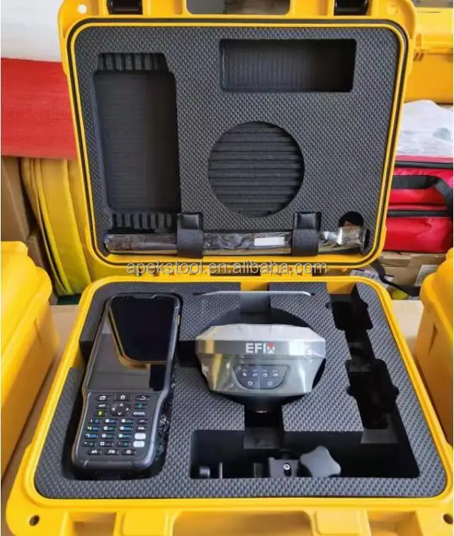
Packages


Company Profile
Shanghai Apekstool was founded and based in Shanghai, specializing in the manufacturing and sales of Surveying equipment. We are dedicated to being a professional provider for survey equipment. Our goal is to provide the best products and excellent service to our customers all over the world.
We are proud to guarantee that, with our strong technical background and communication capability, our sales/support engineers are able to answer your most complicated technical questions over the phone in English. That would save so much time for communication.
We have been involved in the geographic mapping industry for 6 years. We supply all products with reasonable prices and real-time support upon our own professional experience and high-quality supply chain.
We are proud to guarantee that, with our strong technical background and communication capability, our sales/support engineers are able to answer your most complicated technical questions over the phone in English. That would save so much time for communication.
Our business is growing and we invite you to be part of the success.


Contact us

Don't hesitated to send inquiry to us, the top 50 will get discount price!!!
Sales Engineer : Winni Jin
E-mail: winni.jin@apekstool.comWhatsapp/ Wechat /Phone Number: +86 18917981901
To achieve more efficient communication, We'd suggest to talk via Skype /Whatsapp /Wechat telephone directly when you have time.
To achieve more efficient communication, We'd suggest to talk via Skype /Whatsapp /Wechat telephone directly when you have time.
FAQ
Q: Who are we?
We are based in Shanghai, China and we are selling to Middle East, Africa, Southeast Asia, Eastern Asia, South America,North America, In almost every country we have customer representatives who can help us contact you.
Q: How do we process your order and give your warranty?
We can have order by the third party of Alibaba to ensure your order and payment safety.
We will process your order in our sales system, 1. to check machine appearance, 2. to register the machine permanent code, 3. to test machine fixed solution, 4. to pack and delivery. Our sales will follow up every step to the customer, giving you 100% assured experience and immersive online purchasing.
We have 12 months quality warranty and 24 hours online technical support.
Q: What can you buy from us?
We have known brands GNSS RTK system , total station , theodolite , auto level , rotary laser level, drones and surveying
accessories. All products are new and original. Different brands and different price ranges of products can meet the needs of all customers. We can offer one-stop services.
Q: What services can we offer?
Accepted currencies of payment: USD, EUR, JPY, CAD, AUD, HKD, GBP, RMB, CHF.
Accepted payment methods: T/T, L/C, MoneyGram, Credit Card, PayPal, Western Union, Cash
Languages: English, Chinese, Spanish, Japanese,Portuguese,German, Arabic, French, Russian, Korean, Italian
Feedback


We Recommend


New Arrivals
New products from manufacturers at wholesale prices


