
Factory Supply Gps Two Camera 3d Modelling Hi Target V5 Gps Rtk Hi Target V5 Full Set Hi Target Gnsss
- Category: >>>
- Supplier: Shanghai Jice Instrument Co. Ltd.
Share on (1600949538761):
Product Overview
Description
Products Description
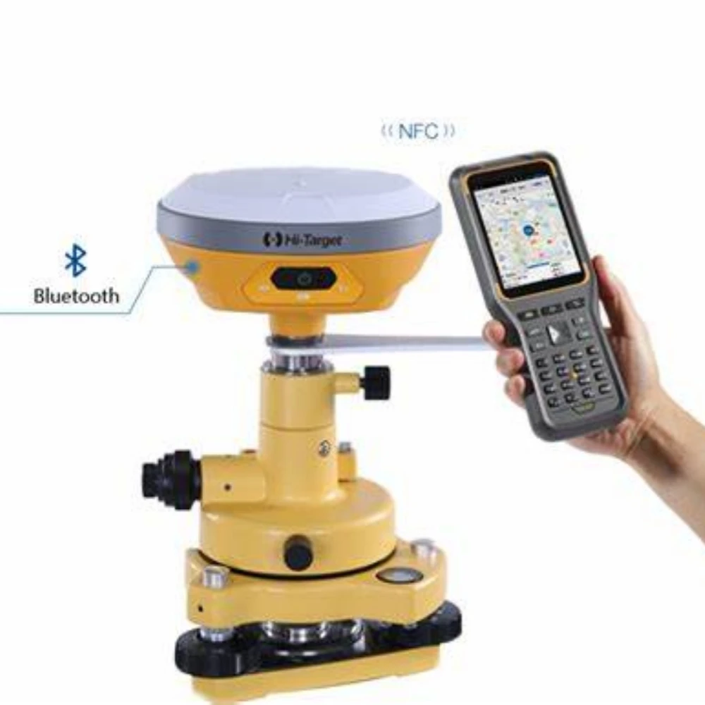
*the New IMU GNSS RTK with Visual Positioning Technology
Equipped with professional dual cameras, vRTK is Hi-Target’s first lightweight and innovative visual RTK receiver product, which not only enables non-contact image surveying, breaking through the objective constraints of previous work, but also improves the speed of stakeout with the function of Live View Stakeout. It greatly improves the work efficiency of engineering users.
* Dual Cameras for Image Survey and Live View Stakeout
Non-contact measurement greatly improves the usable range of GNSS and efficient safe operation.
*Strong Signal and High-quality Data
New generation GNSS SOC chip with 1408 channels, supports new frequency points B1C, B2a, and B2b RTK decoding for Beidou-3
Satellites.
Introduction of multi-frequency anti-jamming technology and multi-step adaptive filtering technology to ensure strong signals, high-quality data, fast fix, and high accuracy.
*Abundant Industry Data Results
Abundant types of data results meet the needs of different industry applications.
Compatible with the mainstream modelling software to attain point cloud and 3D modelling in one step.
Specification
1408 Channels Dual Cameras Visual RTK Receiver V5/vRTK for Land Surveying | ||||
GNSS Configuration | Satellite signals tracked simultaneously | Channels: 1408 | ||
BeiDou: BDS : B1I,B2I,B3I,B1C,B2a,B2b | ||||
GPS: L1C/A,L1C,L2P(Y),L2C,L5 | ||||
GLONASS: L1,L2 | ||||
GALILEO: E1,E5a,E5b,E6 | ||||
SBAS: L1,L2,L5 | ||||
IRNSS :L5 | ||||
QZSS : L1,L2,L5,L6 | ||||
Support the PPP service | ||||
Output format | ASCII: NMEA-0183, binary data | |||
Positioning output frequency | 1-20Hz | |||
Static data format | GNS and Rinex | |||
Differential format | RTCM2.X,RTCM3.X | |||
Network model | VRS, FKP, MAC; support NTRIP | |||
System Configuration | Operating system | Linux | ||
Data storage | Built-in 8GB ROM, support automatic cycle storage of static data | |||
Accuracy and Reliability | RTK Positioning | Horizontal: ±(8+1×10⁻⁶D)mm | ||
Vertical: ±(15+1×10⁻⁶D)mm | ||||
Static Positioning | Horizontal: ±(2.5+0.5×10⁻⁶D)mm | |||
Vertical: ±(5+0.5×10⁻⁶D)mm | ||||
DGPS Positioning | Horizontal:±0.25m+1ppm | |||
Vertical: ±0.50m+1ppm | ||||
SBAS Positioning | 0.5m | |||
Tilt measurement accuracy | 8mm+0.7mm/°tilt | |||
Image stakeout accuracy | Typical accuracy: 2cm | |||
Image measurement accuracy | 2cm ~ 4cm | |||
initialization time | <10s | |||
Initialization reliability | >99.99% | |||
Continued test at breakpoint | RTK measurements are still available during differential signal interruptions | |||
Camera | Pixels | Professional Dual HD Camera, 2MP & 5MP | ||
Futures | Support real scene stakeout, image measurement, working distance 2~15m | |||
Communication | Cellular mobile | Built-in Sim card Internal 4G mobile network:TDD-LTE,FDD-LTE,WCDMA,TD-SCDMA, EDGE,GPRS,GSM | ||
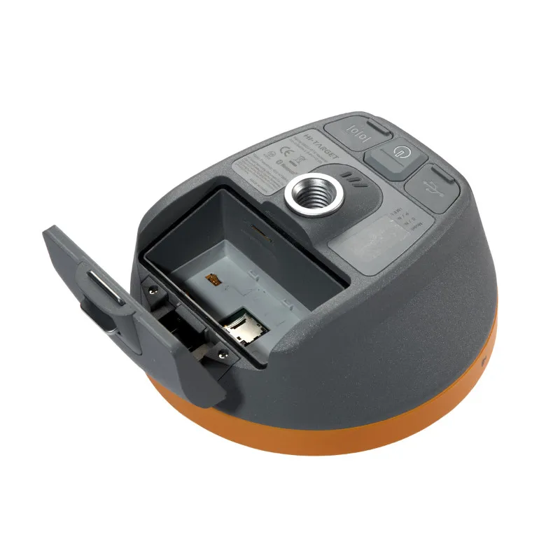
I/O ports | USB type C interface; SMA interface | |||
WiFi | 802.11 b/g access point and client mode, WiFi hotspot available | |||
Bluetooth | Bluetooth® 4.0/2.1+EDR, 2.4GHz | |||
Internal UHF transceiver radio | Transmitting power: 0.5W/1W/2W adjustable | |||
Frequency: 410MHz-470MHz | ||||
Protocol: HI-TARGET,TRIMTALK450S,TRIMMARKⅢTRANSEOT,SOUTH,CHC,SATEL | ||||
Bands: 116 bands(16 bands are configurable) | ||||
Working Range: Typically 7km | ||||
External UHF radio HDL460A radio | Transmitting power: 10W/30W adjustable | |||
Working voltage: 9-16V | ||||
Frequency: 403MHz-473MHz | ||||
Protocol: HI-TARGET,TRIMTALK450S,TRIMMARKⅢTRANSEOT,SOUTH,CHC,SATEL | ||||
Bands: 116 bands(16 bands are configurable) | ||||
Transmission rate: 19.2kbps, 9.6kbps adjustable | ||||
Working Range: Typically 8-10 km ,optimal 15-20 km | ||||
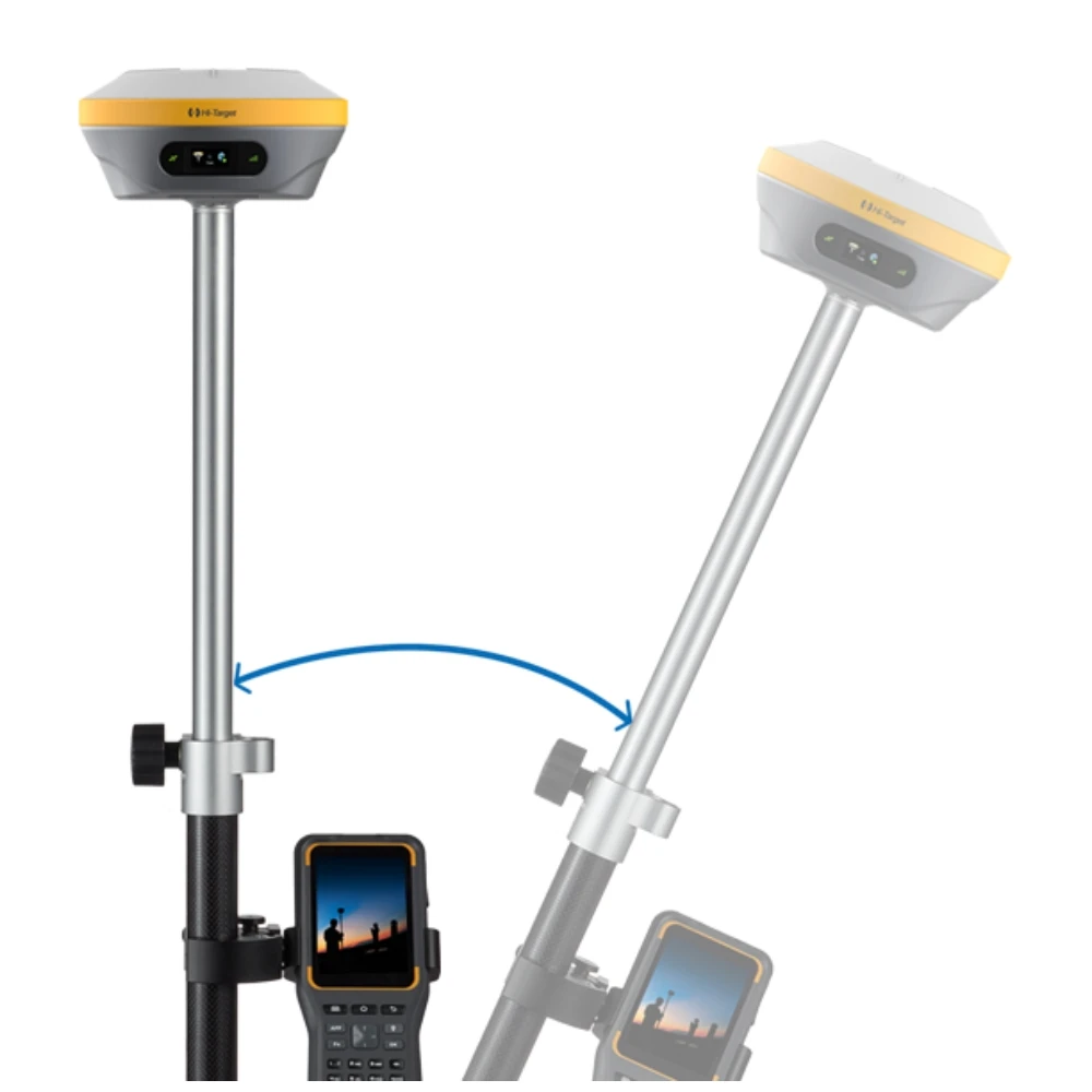
Sensor | Electronic bubble | Intelligent levelling | ||
IMU Tilt survey | Tilt correction system will continue to monitor the inclination of the centering rod, and compensate to correct the coordinates | |||
User Interface | Button | Single button | ||
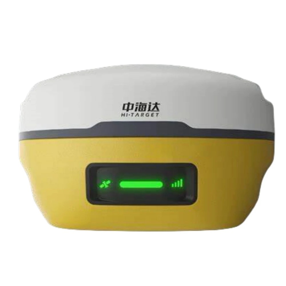
LED Lamp | LED light: satellite light, signal light, power light | |||
Application Function | Advanced function | NFC IGRS, WebUI interaction, U disk firmware upgrade | ||
Intelligence application | intelligent voice, function self-test | |||
Remote service | Message push, online upgrade, remote control | |||
Cloud services | device management, location services, collaborative work, data analysis | |||
Physical | Operating temperature | -45℃~+75℃ | ||
Storage temperature | -55℃~+85℃ | |||
Humidity | 100% non-condensing | |||
Water/dustproof | IP68 dustproof, protected from temporary | |||
Anti-drop | Anti-2m high measuring rod natural drop | |||
GNSS battery | high-capacity li-ion battery 7000mAh, working time is better than 15 hours | |||
External power supply | USB 15W charging | |||
Dimensions | Φ130mm×80mm | |||
Weight | ≤0.97kg | |||
Power | 2.6W | |||
Material | The shell is made of magnesium alloy material | |||
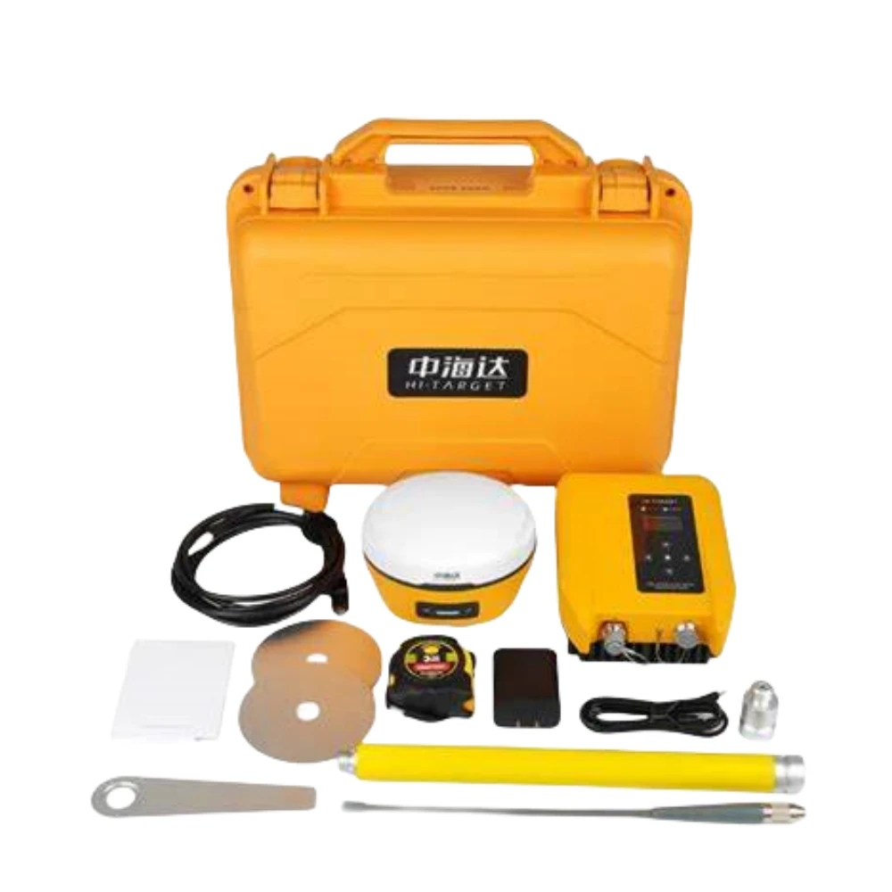
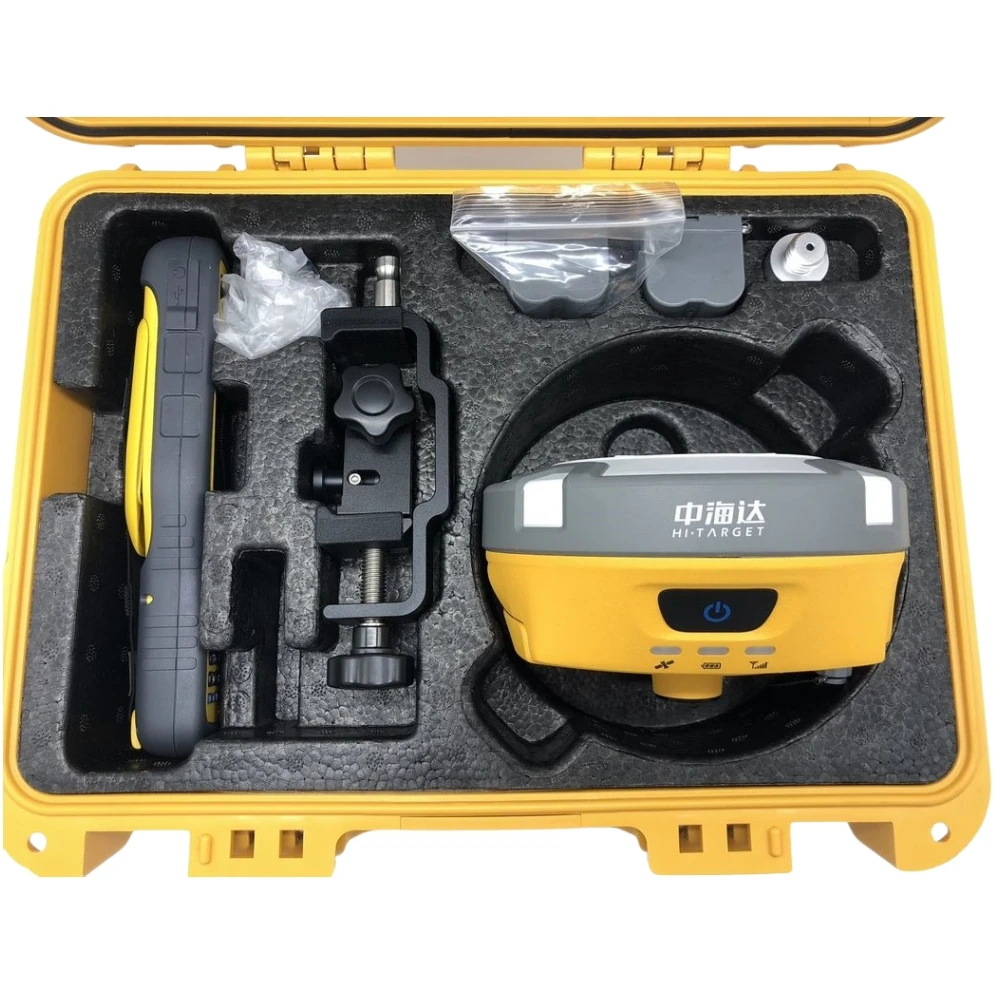
Packages


Company Profile


Shanghai Jice Instrument Co., Ltd. was established in Shanghai, specializing in the manufacturing and sales of measuring
equipment. We are committed to becoming a professional measurement equipment supplier. Our goal is to provide the best products and excellent services to customers around the world.We have been engaged in the geographic surveying and mapping industry for 13 years. We rely on our professional technology and years of cooperation experience with manufacturers to provide you with all the products you need at a reasonable price and provide technical support.
Our business has just started, and we invite you to be a part of success.
SIMILAR PRODUCTS


FAQ
Q:How can you guarantee the safety of my funds?
Trust is always a big problem for international trade, we believe good business credit and reputation is the most important for businessman. We recommend Trade Assurance ser-vice by Alibaba Group. We wont get the fund unless you get the product and confirm the payment.
Q:What Countries do you ship to?
We ships goods to almost all countries by express, air or sea. And we willinform you if we cant ship to your country.
Q: Are your products in stock?
Most items are usually in stock. It all depends on promotions we run, demand at manufac-turers and suppliers. Most delivery will be made within 3-7 working days after payment con-firmed.
Q: Do you have other items that are not displayed on your website?
Yes, we have other items that we do not display on our website. Please contact us and let us know what you are looking for as long as its surveying related.

We Recommend


New Arrivals
New products from manufacturers at wholesale prices


