
R26 GNSS RTK GPS International Surveying Instrument Base Station and Rover
- Category: >>>
- Supplier: SZFP (Shenzhen) Technology Limited
Share on (1601038580349):
Product Overview
Description
Specification
Model | R26 GNSS Receiver | ||
Channels | 432 channels based on Nebulas-Ⅱ | ||
GPS | L1/L2/L5 | ||
GLONASS | L1, L2 | ||
Galileo | E1, E5a , E5b | ||
BeiDou | B1I/B2I | ||
QZSS | L1, L2, L5 | ||
Real time kinematics(RTK) | Horizontal: 8 mm + 1 ppm RMS Vertical: 15 mm + 1 ppm RMS Initialization time:< 5 s Initialization reliability: > 99.9% | ||
Post-processing kinematics (PPK) | Horizontal: 2.5 mm + 1 ppm RMS Vertical: 5 mm + 1 ppm RMS | ||
Post -processing static | Horizontal: 2.5 mm + 0.5 ppm RMS Vertical: 5 mm + 0.5 ppm RMS | ||
Positioning rate | Default 1 HZ, Maximum 20 HZ | ||
Time to first fix | Cold start: < 25 s Hot start: < 10 s Signal re-acquisition: < 1 s | ||
RTK tilt - compensated | Tilt angle 0~60°, Tilt accuracy 25mm (within 30° accuracy) | ||
Size (L x W x H) | 140 mm x 140 mm x 88 mm (5.5 in × 5.5 in × 3.5 in) | ||
Weight | 1.03 kg (2.27 lb) | ||
Environment | Operating: -45°C to +75°C (-49°F to +167°F) Storage: -55°C to +85°C (-67°F to +185°F) | ||
Humidity | 100% condensation | ||
Ingress protection | IP67 waterproof and dustproof, protected from temporary immersionto depth of 2 m | ||
Shock | Survive a 2-meter pole drop | ||
Tilt sensor | Calibration - free IMU for pole - tilt compensation. Immuneto magnetic disturbances. | ||
Front panel | 4 LED indicates 2 physical buttons | ||
Communication | Blue-tooth | v 4.0, Backward compatible with BT2.x | |
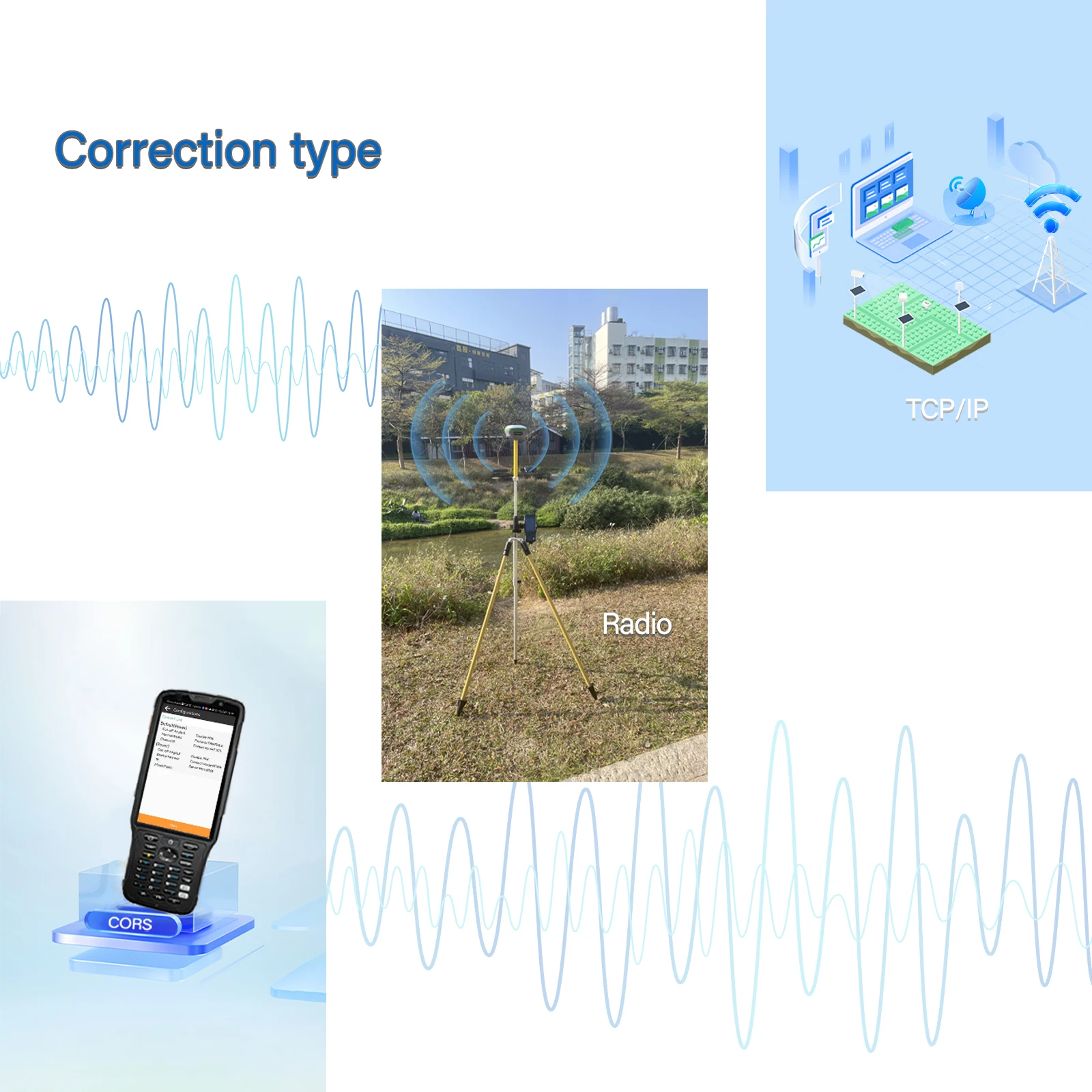
Ports | 1 x 9 PIN aviation plug, including power supply, COM RS232, CONFIG,RS232. 1 x UHF radio antenna interface | ||
Build-in UHF radio | Standard Internal Rx/Tx: 410 - 470 MHz/840MHz Transmit Power: 0.5 W to 2 W Protocol: Transparent, TT450S,Trimtalk, TRMMARK3, SOUTH, SATEL | ||
External Radio | Frequency: 410-470MHz Transmitting power: 35W Working Range: 15-20Km | ||
Data formats | Link rate: 9600 bps to 460800 bps Range: Typical 5 km to 8 km RTCM2.x, RTCM3.x, CMR | ||
Data storage | 8 GB internal memory | ||
Electrical | Power consumption | 5 W (depending on user settings) | |
Li -ion battery capacity | 10200mAh | ||
Operating time on internal battery | 20h(Rover) 10h(Base) | ||
External power input | 9 V DC to 36 V DC | ||
Power consumption | As Rover<4.0W As Base<10.5W | ||
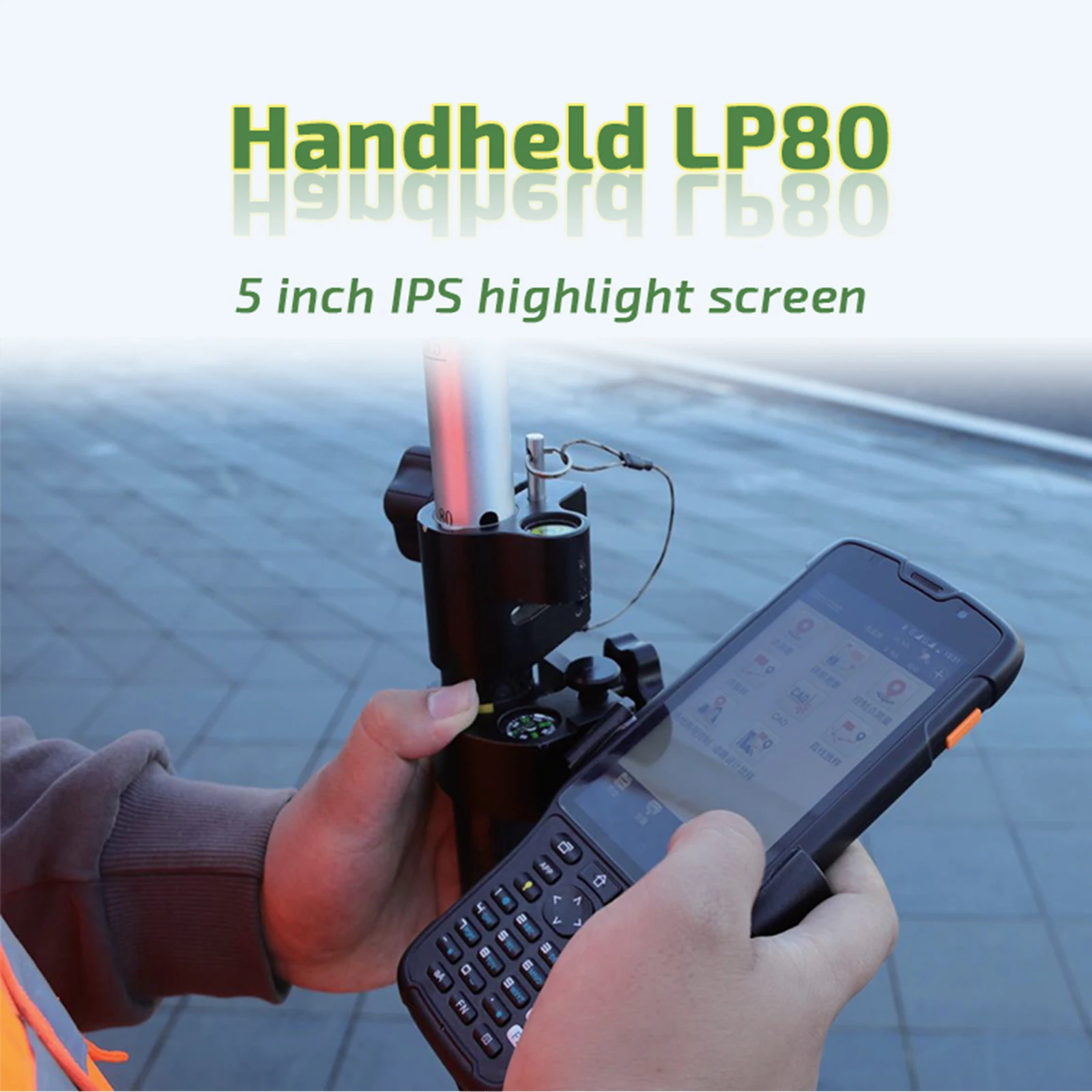
Model | Handheld LP80 |
CPU | 8 cores 2.0GHz |
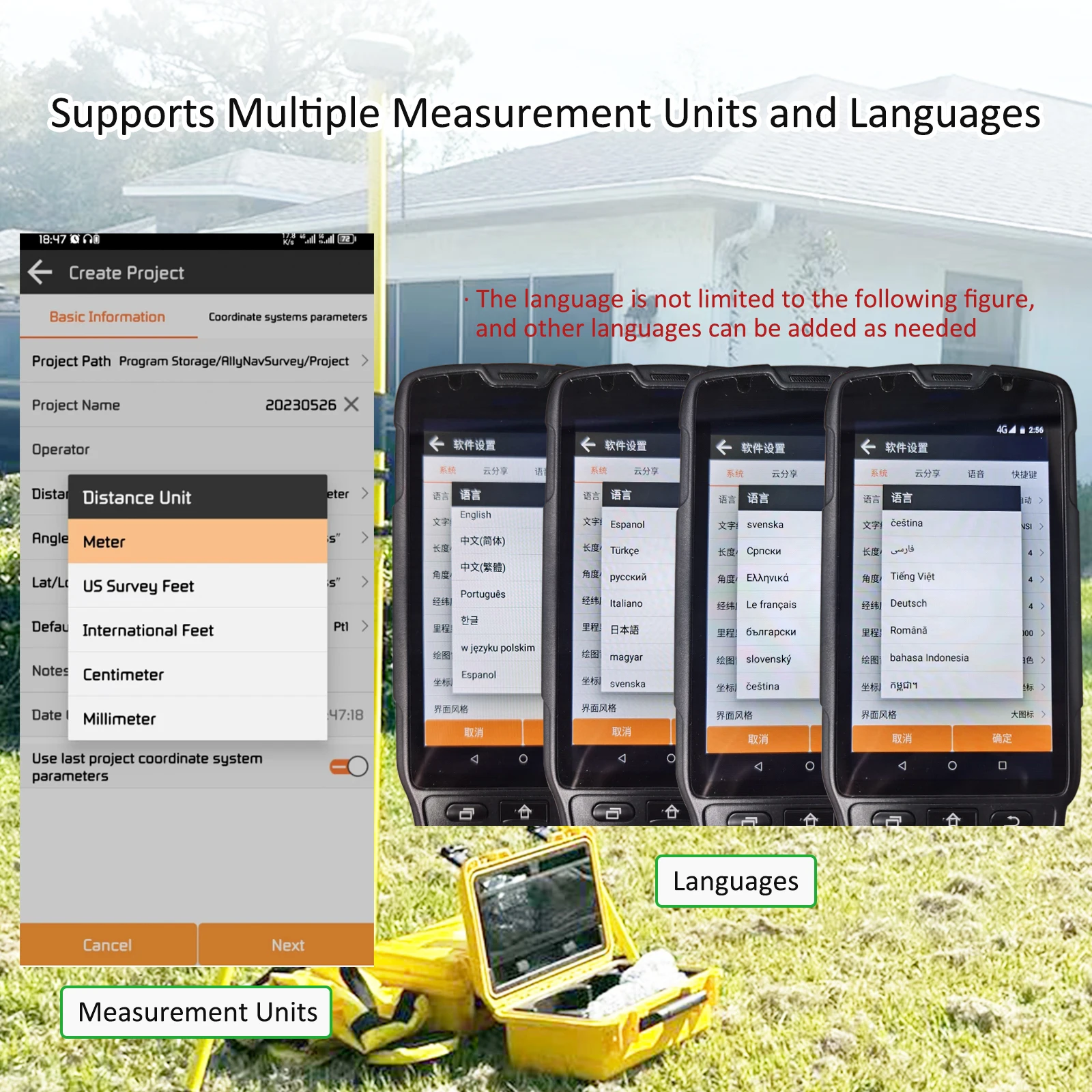
Operating system | Android 8.1 |
RAM | 4GB |
Display size/type | 5 inch IPS highlight screen |
Camera | Rear 13 million auto-focus camera; high-brightness LED flash Front 5 million fixed focus camera |
Resolution | 720*1280 |
Touch screen | 5-point capacitive touch screen |
Dimension | 207*84*20mm |
Weight (including battery) | 360g |
Battery capacity | 7000mAh |
Charging method | PE fast charge, fully charged within 4 hours |
Blue-tooth | BT4.1 BLE |
GPS | GPS+BD+GLONASS |
Data communication | FDD-LTE B1/B3/B5/B7/B8 TDD-LTE B38/B39/B40/B41 TDSCDMA B34/B39 WCDMA B1/B2/B5/B8 GSM B2/B3/B5/B8 CDMA1x/CDMA2000 BC0/BC1 |
Audio | Front dual stereo speakers, volume 90db±3db (test distance 10cm) |
Sensor | Geomagnetism, acceleration, light sensing distance |
Expansion card slot | Expandable up to 128G memory card |
External interface | USB-TypeC, support fast charge, support OTG, Bottom charging contacts for cradle charging |
Button | 30 keys + 2 volume keys + 1 power key |
method to informe | Sound, vibration, LED prompt |
Operating temperature | 20℃ + 55℃ |
storage temperature | -30℃ + 70℃ |
Working humidity | Humidity 5% to 95% |
Certification and test report | CCC、CTA、CE |
Fall | 6 sides can withstand the impact of falling to the concrete floor from a height of 1.5 meters |
Static Protection | ±15kV air discharge, ±8kV contact discharge |
PSAM card (smart encryption card) | optional |
RFID (High Frequency) | Supported protocols: ISO14443A/B, ISO15693, NFC Reading distance: 0~5cm |
Products Description
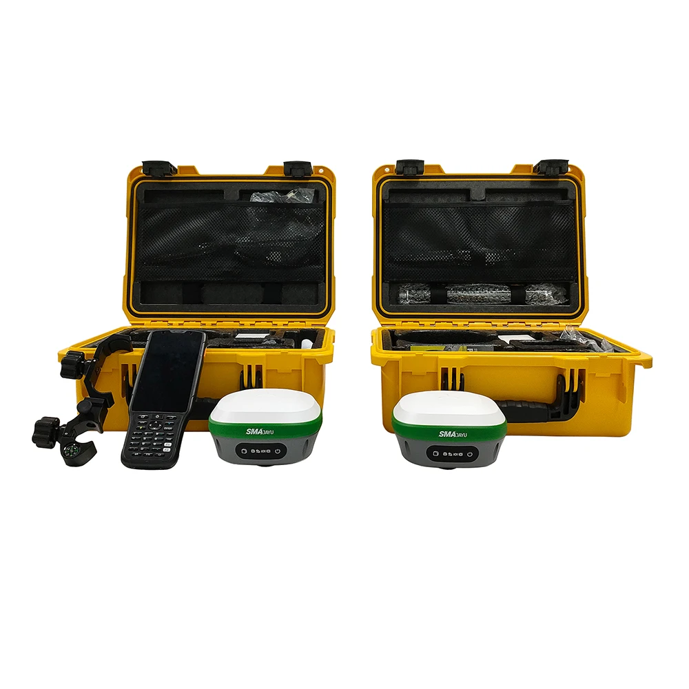
R26 Surveying System Rover+Base
R26 integrated Beidou/GNSS receiver is a built-in large-capacity battery, large-capacity memory card, integrated multi-functional high-precision inertial navigation RTK receiver independently developed by SMAJAYU, built-in Beidou/GNSS full-frequency antenna, and multiple frequency points in the whole system High-precision positioning and orientation boards, Bluetooth, inertial navigation, radio and other modules.
Product packaging


Company Profile

FAQ
1. Who are we?
SMAJAYU is an America registered brand born for agriculture navigation system. And it is developed from SZFP TECH which is a 13 years R&D and marketing experienced professional enterprise in mobile pos terminal field. Its products already deployed in more 30 countries.
SMAJAYU GPS guidance system and auto steering system is designed for new agriculture and is completed system including software and hardware for precision and intelligent farming.
2. How can we guarantee quality?
IP67 level protection
Remote faulty diagnosis which can help farmer wherever you are!
Remote software upgrade supported.
Always a pre-production and market testing before mass production;
Always final Inspection before shipment;
3.What can you buy from us?
EFT POS Terminal,Mobile POS,and PDA solution with agriculture system
4. Why should you buy from us not from other suppliers?
Smajayu Agriculture Navigation system is the first and the most used in China agriculture field.
Experienced team in Agriculture navigation system.
Great Quality recognized and praised by buyer.
5. What are the terms to buy ?
Accepted Delivery Terms: EXW,FCA,CPT,DDU,Express Delivery;
Accepted Payment Currency:USD,EUR,AUD,HKD,GBP,CNY;
Accepted Payment Type: T/T,PayPal,Western Union;
24 hours online service for help.
We Recommend


New Arrivals
New products from manufacturers at wholesale prices


