
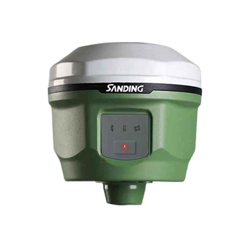
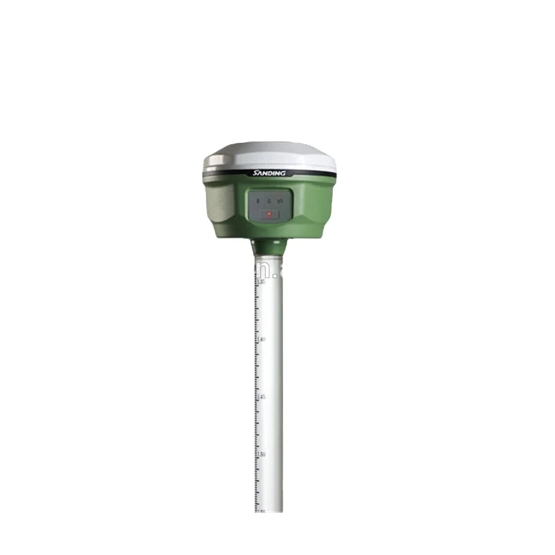
Small rugged RTK gnss receiver SANDING T66 gps survey equipment gps for land survey
- Category: >>>
- Supplier: Suzhou Super Gis Technology Co. Ltd.
Share on (60765654690):
Product Overview
Description
Product Description
Model | T66 | |||||
Surveying Performance | ||||||
No. of Channel | ¡¡ | 220 | ||||
Signal Tracking | BDS | B1, B2, B3 | ||||
¡¡ | GPS | L1C/A, L1C, L2C, L2E, L5 | ||||
¡¡ | GLONASS | L1C/A, L1P, L2C/A, L2P, L3 | ||||
¡¡ | Galileo | GIOVE-A, GIOVE-B, E1, E5A, E5B | ||||
¡¡ | SBAS | L1C/A, L5 (only for the satellites supporting L5) | ||||
¡¡ | ¡¡ | QZSS, WAAS, MSAS, EGNOS, GAGAN, SBAS | ||||
GNSS Features | Positioning output rate: | 1Hz~50Hz | ||||
Initialization time: | < 10s | |||||
Initialization reliability: | >99.99% | |||||
Positioning Precision | ||||||
Code Differential | Horizontal: | ±0.25 m + 1 ppm | ||||
Vertical: | ±0.50 m + 1 ppm | |||||
SBAS | typically<5m 3DRMS | |||||
Static Performance | Horizontal: | ±2.5 mm + 0.5 ppm | ||||
Vertical: | ±5 mm + 0.5 ppm | |||||
Realtime Kinematic | Horizontal: | ±8 mm + 1 ppm | ||||
(Baseline<30km) | Vertical: | ±15 mm + 1 ppm | ||||
Network RTK | Horizontal: | ±8 mm + 0.5 ppm | ||||
Vertical: | ±15 mm + 0.5 ppm | |||||
RTK initialization time: | 2~8s | |||||
Physical | Dimension | 12.9 cm X 11.2cm | ||||
Weight | 970g (including installed battery) | |||||
Material | Magnesium aluminum alloy shell | |||||
Electrical | Power Consumption | 2W | ||||
Battery | Rechargeable, removable Lithium-ion battery | |||||
Battery Life | Single battery: 7h (static mode) | |||||
5h (internal UHF base mode) | ||||||
6h (rover mode) | ||||||
Environmental | ||||||
Operating Temp. | -45°C to 60°C (-49°F to 140°F) | |||||
Storage Temp. | -55°C to 85°C (-67°F to 185°F) | |||||
Humidity | Non-condensing | |||||
Waterproof | IP67 standard, protected from long time immersion to depth of 1m | |||||
Dustproof | IP67 standard, fully protected against blowing dust | |||||
Shock and Vibration | OFF Status: Withstand 2 meters pole drop onto the cement ground naturally. | |||||
ON Status: Withstand 40G 10 milliseconds sawtooth wave impact test. | ||||||
Communications and Data Storage | ||||||
I/O Port | 5PIN LEMO external power port + RS232 | |||||
7PIN LEMO RS232 + USB | ||||||
1 network/radio data link antenna port | ||||||
SIM card slot | ||||||
Wireless Modem | Integrated internal radio receiver and transmitter 0.5W/1W | |||||
External radio transmitter 5W/25W | ||||||
Working frequency | 410-470MHz | |||||
Communication protocol | TrimTalk450s, TrimMark3, PCC EOT, SOUTH | |||||
Cellular Mobile Network | WCDMA 3.5G module, GPRS/EDGE compatible, CDMA2000/EVDO 3G optional | |||||
Double Module Bluetooth | BLEBluetooth 4.0 standard, supports connection with Android and iOS. | |||||
Bluetooth 2.1 + EDR standard | ||||||
NFC Communication | Realizing close range (<10cm) automatic pair between T66 and controller | |||||
(controller equipped with NFC wireless communication module is required.) | ||||||
DataStorage/Transmission | 4GB internal storage, more than 3 years’ raw observation data (about 1.4M/day), | |||||
based on recording from 14 satellites plug and play mode of USB data transmission. | ||||||
Data Format | Differential: CMR+, CMRx, RTCM 2.1, RTCM 2.3, RTCM 3.0, RTCM 3.1, RTCM 3.2 | |||||
GPS output: NMEA 0183, PJK plane coordinates, binary code | ||||||
Network model support: VRS, FKP, MAC, supporting NTRIP protocol | ||||||
Inertial Sensing System | ||||||
Tilt Survey | Built-in tilt compensator, correcting coordinates automatically according to the | |||||
tilt direction and angle of the centering rod | ||||||
Electronic Bubble | Controller software display electronic bubble, checking leveling status of the | |||||
centering rod real time | ||||||
User Interaction | ||||||
Buttons | One-button operation, visual operation | |||||
KEY FEATURES
1.220 channels, support GPS/GLONASS/Galileo/BeiDou/SBAS
2.SuperRTK technology : Radio Router/ Radio Repeater/Eagle mode/CSD model/LARK mode
3.Buil-in radio modem with 1/2/3W
4.Built-in network modem (4G/3G/2G) and UHF data transmission
5.8Gb SDD Built-in Memory; OTG function,for downloading data in field
6.Tilt Survey and E-Bubble function
7.Small, lightweight and robust design suitable for a diverse work environment
Specification
Packing & Delivery

Company Profile


At SUPERGIS we pride ourselves on the quality and range of products and services we offer to our customers. We supply everything from the simplest of survey accessory such as nails or spray paintthrough to the full range of surveying equipment, total stations and RTK.
With years of experience in providing a quality service to the civil engineering, surveying and construction industries we are committed to innovating the service we can provide to our customers by adding new innovative products,solutions and services to our customers.
With years of experience in providing a quality service to the civil engineering, surveying and construction industries we are committed to innovating the service we can provide to our customers by adding new innovative products,solutions and services to our customers.
Our service
Customer Care
At our Customer Service department, we receive your enquiries, compliments and complaints and channel them to those deserving. We also follow up on your complaints and queries to ensure that you get immediate answers to all your enquiries.
For queries that require investigation and consultation, we ensure to get the expert and let you know the status within reasonable time.
FAQ
HOW IS THE EXPORT SERVICES ?
We offer a comprehensive and efficient export service including:
* Packaging and transportation worldwide
* Insurance where required
* Customs documentation
WILL THE PRICE OF YOUR PRODUCTS EVER CHANGE?
All prices are shown in USD (United States Dollar). All goods are sold subject to availability. Both price and availability information is subject to change without notice, hence any subsequent purchases of the same product cannot be guaranteed at the same price. While we take the utmost care to ensure the product descriptions, pictures, information and prices are accurate we do not accept liability for any inaccuracies, errors or omissions. Despite our best efforts, a small number of items displayed on our
site may be mispriced.
WHAT ARE THE SHIPPING CHARGES ?
Shipping and handling charges are based on order weight.
ARE ALL OF YOUR PRODUCTS SHOWN ONLINE?
Not all of our products are shown online,Please contact us and let us know what you are looking for. Chances are we can find it, as long as its surveying related.
WHATS YOUR PAYMET METHOD ?
We accept wire transfer ,paypal,moneygram,western union and Alibaba Trade Assurance online payment (credit card )
HOW CAN YOU MAKE SURE MY PAYMENT IS SAFE?
We can make deal on Alibaba Trade Assurance if the trust problem exist as Alibaba as the third party will guarantee your payment until you receive your order and confirm everything is all right .
WHAT ABOUT THE WARRANTY OF YOUR INSTRUMENT ?
We offer one year warranty of GNSS,TOTAL STATION,THEODOLITE AND AUTO LEVEL.
YOU MAY LIKE


Contact us
JESSICA JIANG
SKYPE:JESSICA JIANG71
TEL:0512-50128487
MOBILE:+86-18772319050
ADD:RM365,BLD3,NO258,LVDI RD,SUZHOU,CHINA
SKYPE:JESSICA JIANG71
TEL:0512-50128487
MOBILE:+86-18772319050
ADD:RM365,BLD3,NO258,LVDI RD,SUZHOU,CHINA
We Recommend


New Arrivals
New products from manufacturers at wholesale prices


