

High Reliable Sino gnss Comnav T300 Gps Rtk Compatible With Trimble Rtk Gps
- Category: >>>
- Supplier: Suzhou Super Gis Technology Co. Ltd.
Share on (62533980770):
Product Overview
Description
Product Description
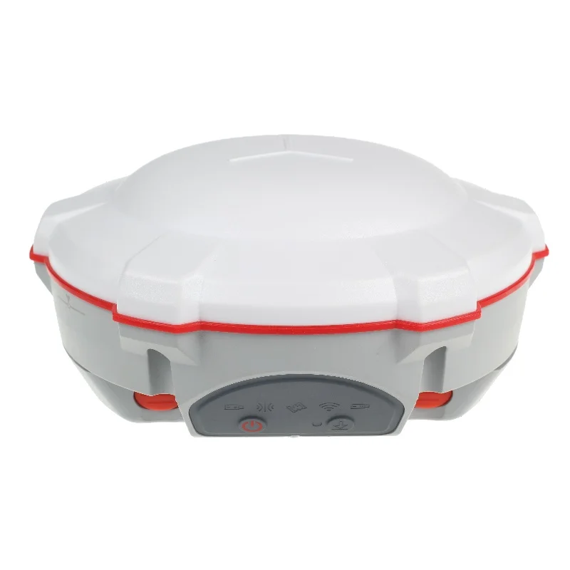
SinoGNSS T300 GNSS receiver is a compact RTK GNSS receiver tracking all working constellations, combines 4G/TX & RX into one device, and work fluently with Android-based Survey Master software, for centimeter accuracy survey on demand.
Features
Online customer service
GPS L1/L2/L5, BeiDou B1/B2/B3,GLONASS L1/L2, Galileo E1/E5a/E5b
Compact Design
Hot Swap Battery
User-friendly Interface
Built-in 4G/UHF
The T300 tracks all working and planned GNSS constellations including GPS, GLONASS, BeiDou, Galileo and SBAS.
Built-in GPRS/ GSM/4G modem ensures the T300 seamlessly work with all kinds of CORS, and 0 – 2 Watt internal UHF allows you more convenient and effective field work
The T300 is able to provide easier survey workflow via Survey Master, improving productivity for both beginners and professional surveyors.
RELIABLE IN THE FIELD
SinoGNSS T300 GNSS receiver is a compact RTK GNSS receiver tracking all working constellations, which performs well with each constellation independently. With SinoGNSS QUANTM technology and its strong anti-interference design, the T300 provides high-accuracy position availability and reliability no matter where you are.
RUGGED AND EASE OF USE
The rugged housing with IP67 Dustproof & Waterproof design makes the T300 perfectly and effectively work even in harsh
environments. Small volume with less than 1kg weight makes the T300 one of portable GNSS receivers meeting your RTK survey demands. Bulit-in 8GB internal memory enlarges your data storage in the field.
INTEGRATED GNSS RECEIVER
The T300 GNSS receiver combines a GNSS board, Bluetooth® and adjustable TX & RX UHF into one compact device, which is one of the most reliable choices for any surveying tasks. Built-in GPRS/ GSM/4G modem ensures the T300 seamlessly work with all kinds of CORS.
SMART BATTERY DESIGN
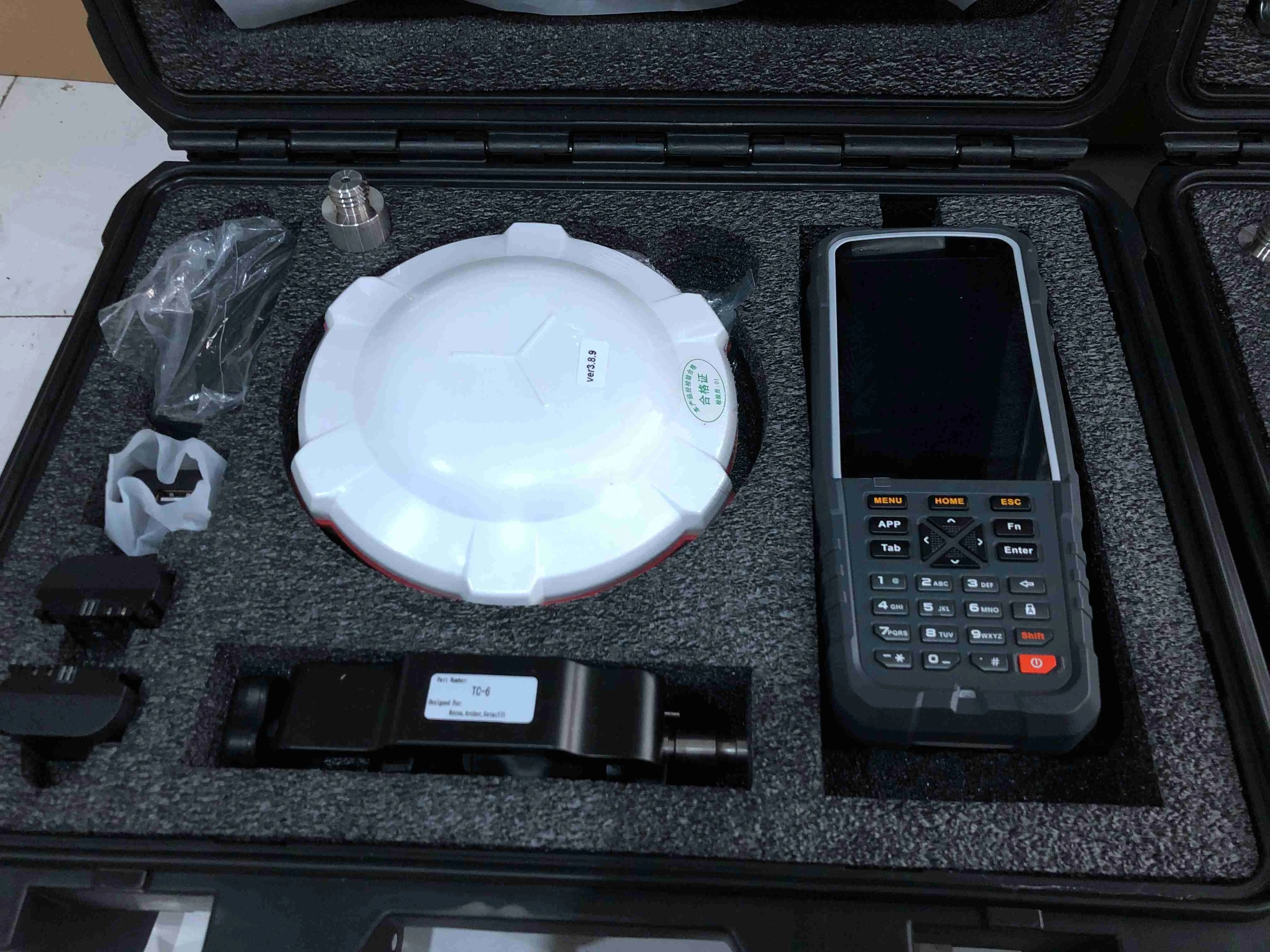
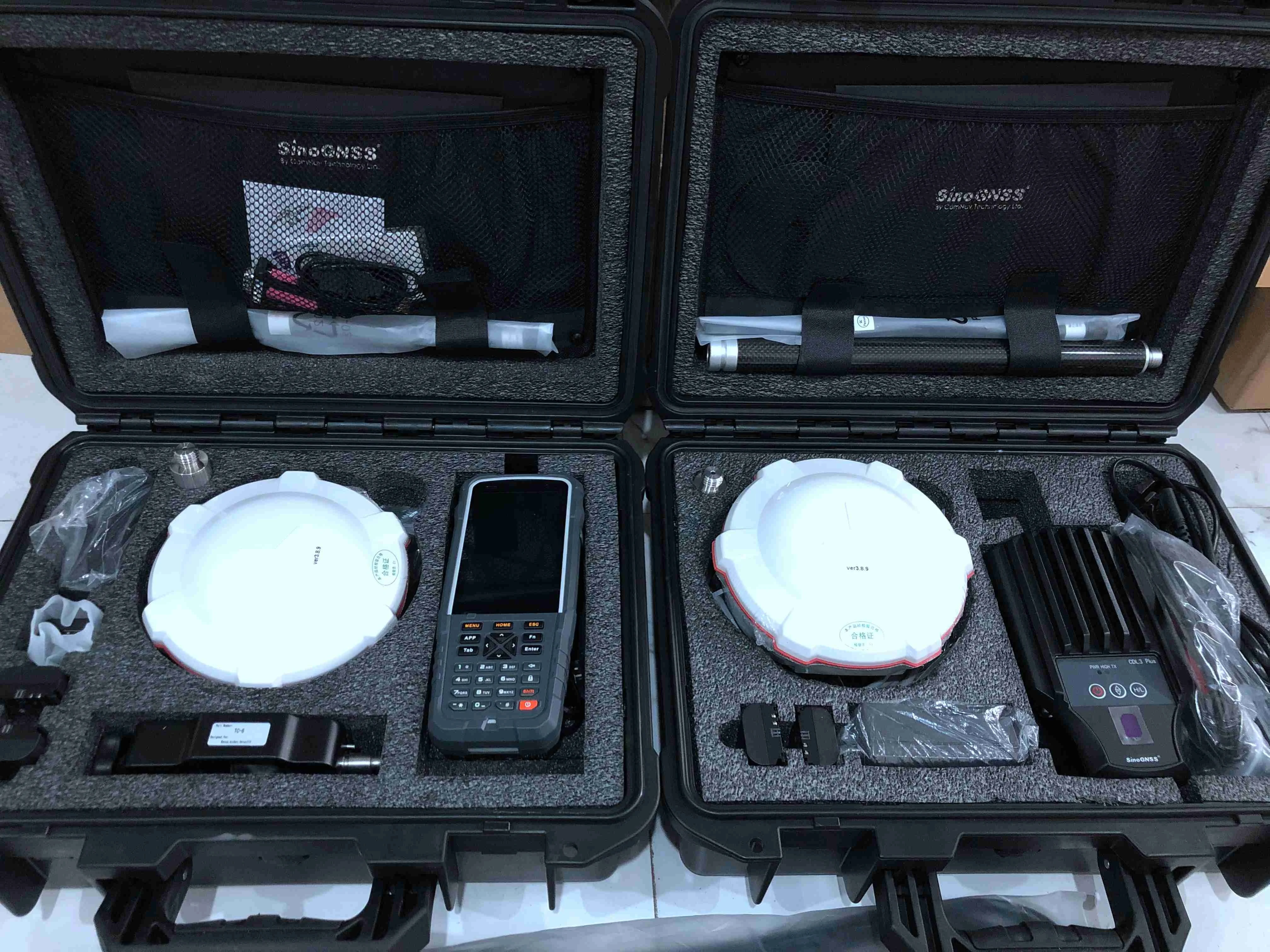
With two hot swap batteries, the T300 helps to extend working hours and ensure your fluent workflow in the field. The battery LEDs flash when battery shortage. Moreover, you will benefit from its consumer-grade battery design, compatible with Canon LP-E6, which is easy to purchase and replace in your local market.
Features
Online customer service
GPS L1/L2/L5, BeiDou B1/B2/B3,GLONASS L1/L2, Galileo E1/E5a/E5b
Compact Design
Hot Swap Battery
User-friendly Interface
Built-in 4G/UHF
The T300 tracks all working and planned GNSS constellations including GPS, GLONASS, BeiDou, Galileo and SBAS.
Built-in GPRS/ GSM/4G modem ensures the T300 seamlessly work with all kinds of CORS, and 0 – 2 Watt internal UHF allows you more convenient and effective field work
The T300 is able to provide easier survey workflow via Survey Master, improving productivity for both beginners and professional surveyors.
RELIABLE IN THE FIELD
SinoGNSS T300 GNSS receiver is a compact RTK GNSS receiver tracking all working constellations, which performs well with each constellation independently. With SinoGNSS QUANTM technology and its strong anti-interference design, the T300 provides high-accuracy position availability and reliability no matter where you are.
RUGGED AND EASE OF USE
The rugged housing with IP67 Dustproof & Waterproof design makes the T300 perfectly and effectively work even in harsh
environments. Small volume with less than 1kg weight makes the T300 one of portable GNSS receivers meeting your RTK survey demands. Bulit-in 8GB internal memory enlarges your data storage in the field.
INTEGRATED GNSS RECEIVER
The T300 GNSS receiver combines a GNSS board, Bluetooth® and adjustable TX & RX UHF into one compact device, which is one of the most reliable choices for any surveying tasks. Built-in GPRS/ GSM/4G modem ensures the T300 seamlessly work with all kinds of CORS.
SMART BATTERY DESIGN
With two hot swap batteries, the T300 helps to extend working hours and ensure your fluent workflow in the field. The battery LEDs flash when battery shortage. Moreover, you will benefit from its consumer-grade battery design, compatible with Canon LP-E6, which is easy to purchase and replace in your local market.
Specification
Mode | Accuracy |
Static and Fast Static | 2.5 mm + 0.5 ppm Horizontal 5 mm + 0.5 ppm Vertical |
Long Observations Static | 3 mm + 0.1 ppm Horizontal 3.5 mm + 0.4 ppm Vertical |
Real Time Kinematic | 8 mm + 1 ppm Horizontal 15 mm + 1 ppm Vertical |
E-RTK (<100 km) | 0.2m + 1 ppm Horizontal 0.4m + 1 ppm Vertical |
DGPS | <0.4 m RMS |
SBAS | 1 m 3D RMS |
Standalone | 1.5 m 3D RMS |
Signal Tracking
* 572 channels with simultaneously tracked satellite signals
- GPS: L1, L2, L2C, L5
- BeiDou: B1, B2, B3
- BeiDou Global Signal: B1C, B2a2
- GLONASS: L1, L2
- Galileo: E1, E5a, E5b
- QZSS (Reserved)
- SBAS: WAAS, EGNOS, MSAS, GAGAN
Performance Specifications
* Cold start: 99.9%
* Warm start: 99.9%
* Hot start: 99.9%
* Initialization time: 99.9%
* Singal re-acquisition:<1.5S
Communications
* 1 Serial port (7 pin Lemo) Baud rates up to 921,600 bps
* UHF modem3: Tx/Rx with full frequency range from 410-470 MHz4
- Transmit power: 0.5-2 W adjustable
- Range: 1-5 km5
* 4G modem
- 4G Bands: 800/900/1800/2100/2600 MHz
- 3G Bands: 900/2100 MHz
- 2G Bands: 900/1800 MHz
- Support GSM, Point to Point/Points and NTRIP
* Position data output rates: 1 Hz, 2 Hz, 5 Hz, 10 Hz, 20 Hz
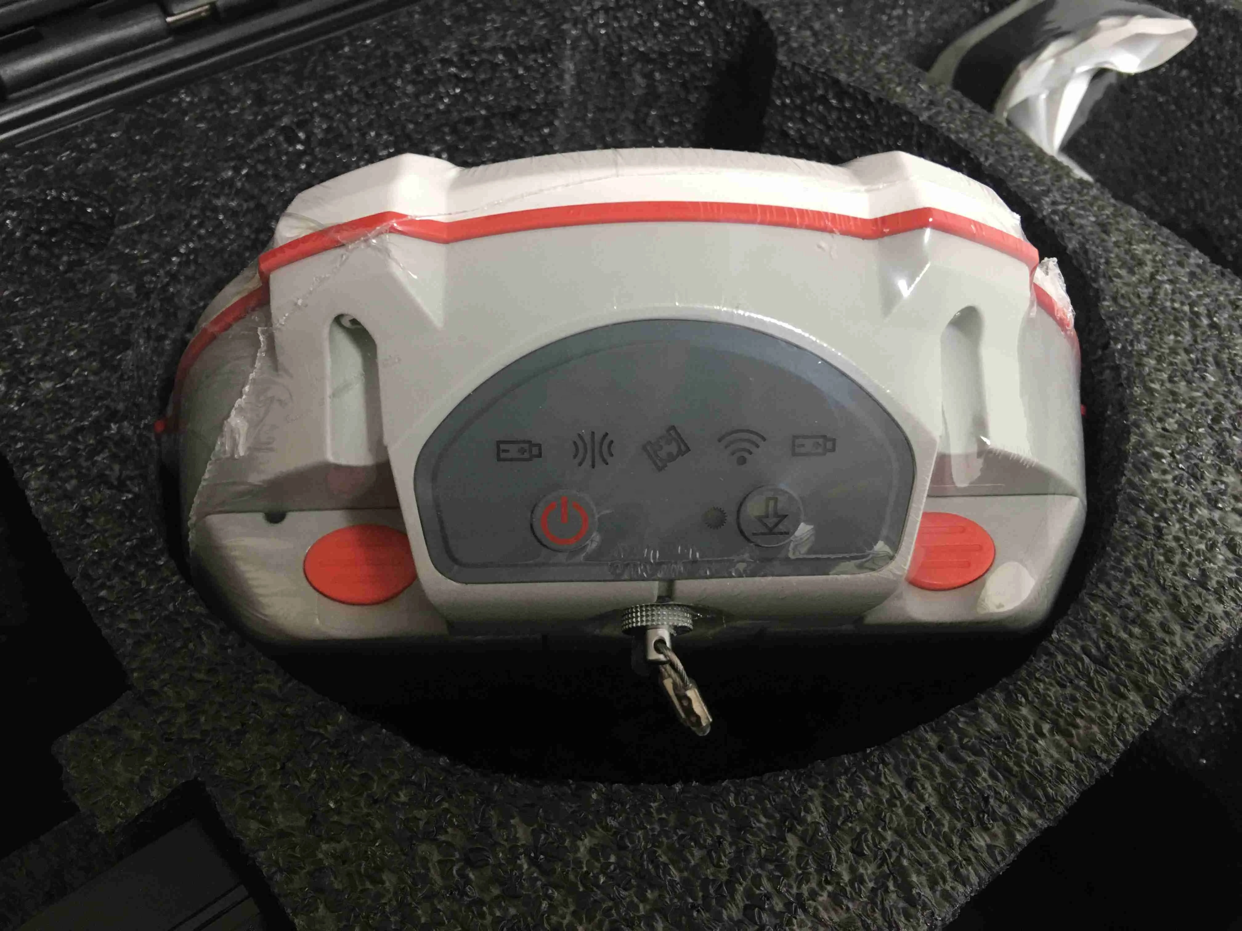
* 5 LEDs (indicating Power, Satellite Tracking, GPRS Status and Differential Data)
* Bluetooth® : V 4.0 protocol, compatible with Windows OS and Android OS
Data Format
* Correction data I/O: - RTCM SC104 Version 2.x, 3.x formats,CMR(GPS only),CMR+(GPS only)
* Position data output: - ASCII: NMEA-0183 GSV, RMC, HDT, VHD, GGA, GSA, ZDA, VTG, GST; PTNL, PJK; PTNL, AVR; PTNL, GGK - ComNav
Binary update to 20 Hz Physical
* Size(W × H): Φ 15.8 cm × 7.5 cm
* Weight: 0.95 kg with two batteries Environmental
* Operating temperature: -40 °C to + 65 °C (-40 °F to 149 °F)
* Storage temperature: -40 °C to + 85 °C (-40 °F to 185 °F)
* Humidity: 100% non-condensing
* Waterproof and dustproof: IP67, protected from temporary immersion to depth of 1 m
* Shock: Designed to survive a 2 m drop onto concrete Electrical and Memory • Input voltage: 5-27 VDC
* Power consumption: 3.1 W6
* Li-ion battery capacity: 2 × 2000 mAh, up to 9 hours typically
* Memory: 8 GB7 Software
* CGSurvey field data collection software
* Survey Master Android-based data collection software
* Carlson SurvCE field data collection software (optional)
* MicroSurvey FieldGenius field data collection software (optional)
* 572 channels with simultaneously tracked satellite signals
- GPS: L1, L2, L2C, L5
- BeiDou: B1, B2, B3
- BeiDou Global Signal: B1C, B2a2
- GLONASS: L1, L2
- Galileo: E1, E5a, E5b
- QZSS (Reserved)
- SBAS: WAAS, EGNOS, MSAS, GAGAN
Performance Specifications
* Cold start: 99.9%
* Warm start: 99.9%
* Hot start: 99.9%
* Initialization time: 99.9%
* Singal re-acquisition:<1.5S
Communications
* 1 Serial port (7 pin Lemo) Baud rates up to 921,600 bps
* UHF modem3: Tx/Rx with full frequency range from 410-470 MHz4
- Transmit power: 0.5-2 W adjustable
- Range: 1-5 km5
* 4G modem
- 4G Bands: 800/900/1800/2100/2600 MHz
- 3G Bands: 900/2100 MHz
- 2G Bands: 900/1800 MHz
- Support GSM, Point to Point/Points and NTRIP
* Position data output rates: 1 Hz, 2 Hz, 5 Hz, 10 Hz, 20 Hz
* 5 LEDs (indicating Power, Satellite Tracking, GPRS Status and Differential Data)
* Bluetooth® : V 4.0 protocol, compatible with Windows OS and Android OS
Data Format
* Correction data I/O: - RTCM SC104 Version 2.x, 3.x formats,CMR(GPS only),CMR+(GPS only)
* Position data output: - ASCII: NMEA-0183 GSV, RMC, HDT, VHD, GGA, GSA, ZDA, VTG, GST; PTNL, PJK; PTNL, AVR; PTNL, GGK - ComNav
Binary update to 20 Hz Physical
* Size(W × H): Φ 15.8 cm × 7.5 cm
* Weight: 0.95 kg with two batteries Environmental
* Operating temperature: -40 °C to + 65 °C (-40 °F to 149 °F)
* Storage temperature: -40 °C to + 85 °C (-40 °F to 185 °F)
* Humidity: 100% non-condensing
* Waterproof and dustproof: IP67, protected from temporary immersion to depth of 1 m
* Shock: Designed to survive a 2 m drop onto concrete Electrical and Memory • Input voltage: 5-27 VDC
* Power consumption: 3.1 W6
* Li-ion battery capacity: 2 × 2000 mAh, up to 9 hours typically
* Memory: 8 GB7 Software
* CGSurvey field data collection software
* Survey Master Android-based data collection software
* Carlson SurvCE field data collection software (optional)
* MicroSurvey FieldGenius field data collection software (optional)
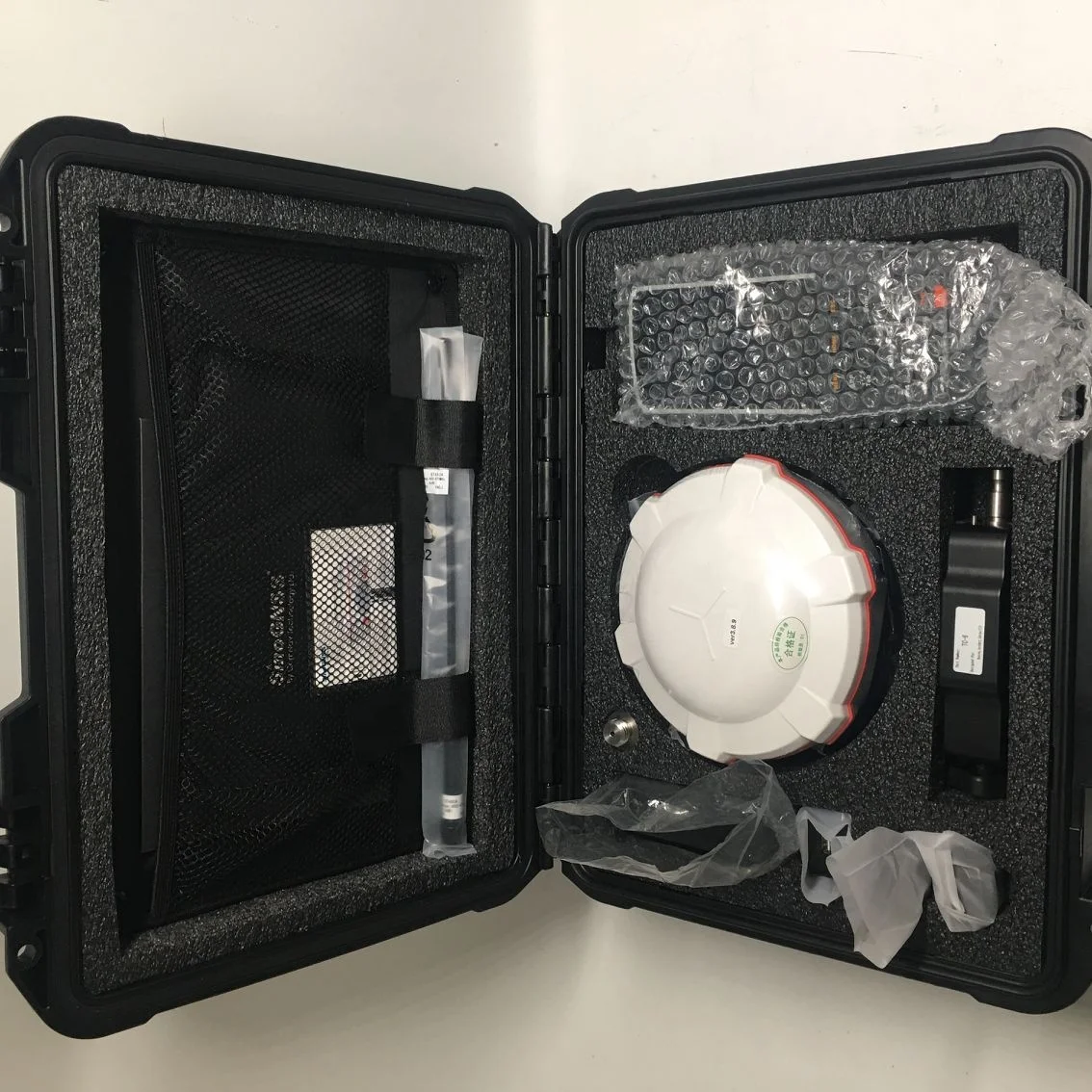
Packing & Delivery

Company Profile


At SUPERGIS we pride ourselves on the quality and range of products and services we offer to our customers. We supply everything from the simplest of survey accessory such as nails or spray paintthrough to the full range of surveying equipment, total stations and RTK.
With years of experience in providing a quality service to the civil engineering, surveying and construction industries we are committed to innovating the service we can provide to our customers by adding new innovative products,solutions and services to our customers.
With years of experience in providing a quality service to the civil engineering, surveying and construction industries we are committed to innovating the service we can provide to our customers by adding new innovative products,solutions and services to our customers.
Our service
Customer Care
At our Customer Service department, we receive your enquiries, compliments and complaints and channel them to those deserving. We also follow up on your complaints and queries to ensure that you get immediate answers to all your enquiries.
For queries that require investigation and consultation, we ensure to get the expert and let you know the status within reasonable time.
FAQ
HOW IS THE EXPORT SERVICES ?
We offer a comprehensive and efficient export service including:
* Packaging and transportation worldwide
* Insurance where required
* Customs documentation
WILL THE PRICE OF YOUR PRODUCTS EVER CHANGE?
All prices are shown in USD (United States Dollar). All goods are sold subject to availability. Both price and availability information is subject to change without notice, hence any subsequent purchases of the same product cannot be guaranteed at the same price. While we take the utmost care to ensure the product descriptions, pictures, information and prices are accurate we do not accept liability for any inaccuracies, errors or omissions. Despite our best efforts, a small number of items displayed on our
site may be mispriced.
WHAT ARE THE SHIPPING CHARGES ?
Shipping and handling charges are based on order weight.
ARE ALL OF YOUR PRODUCTS SHOWN ONLINE?
Not all of our products are shown online,Please contact us and let us know what you are looking for. Chances are we can find it, as long as its surveying related.
WHATS YOUR PAYMET METHOD ?
We accept wire transfer ,paypal,moneygram,western union and Alibaba Trade Assurance online payment (credit card )
HOW CAN YOU MAKE SURE MY PAYMENT IS SAFE?
We can make deal on Alibaba Trade Assurance if the trust problem exist as Alibaba as the third party will guarantee your payment until you receive your order and confirm everything is all right .
WHAT ABOUT THE WARRANTY OF YOUR INSTRUMENT ?
We offer one year warranty of GNSS,TOTAL STATION,THEODOLITE AND AUTO LEVEL.
YOU MAY LIKE


Contact us
JESSICA JIANG
SKYPE:JESSICA JIANG71
TEL:0512-50128487
MOBILE:+86-18772319050
ADD:RM365,BLD3,NO258,LVDI RD,SUZHOU,CHINA
SKYPE:JESSICA JIANG71
TEL:0512-50128487
MOBILE:+86-18772319050
ADD:RM365,BLD3,NO258,LVDI RD,SUZHOU,CHINA
We Recommend


New Arrivals
New products from manufacturers at wholesale prices


